place

Elmwood, Berkeley, California
Alameda County, California geography stubsNeighborhoods in Berkeley, CaliforniaStreetcar suburbs
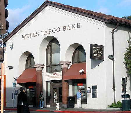
Berkeley Wells Fargo

The Elmwood District is a neighborhood of the City of Berkeley, California. It is primarily residential, with a small commercial area. The district does not have set lines of demarcation, but is focused around College and Ashby Avenues. The most extreme definitions of the district's boundaries do not extend past Telegraph Avenue to the west, Dwight Way to the north, or the Oakland city limit to the south. Elmwood was a streetcar suburb that was developed in the 1900s housing boom following the 1906 San Francisco earthquake, and was the first Berkeley subdivision to be assigned single-family residential zoning.It has a small commercial corridor on College Avenue, centered on the intersection of Ashby and College Avenues, that spans College Avenue about one to two blocks in each direction. The commercial corridor consists of small shops and restaurants that cater to local residents. There is also a small movie theater and a bank near the intersection. There are also a handful of businesses near the intersection of College Avenue and Derby Street. Elmwood was developed as a de facto segregated neighborhood, reinforced by Federal Housing Administration–guaranteed mortgages, which were not issued to African Americans. Homes purchased with FHA-guaranteed mortgages were closely scrutinized to ensure segregation was maintained. In one noted 1958 incident, a white San Francisco schoolteacher, Gerald Cohn, purchased a house with an FHA-guaranteed mortgage in Elmwood. By the closing date, Cohn was not ready to inhabit the property; while continuing to pay the mortgage, Cohn rented the house to a fellow teacher, Alfred Simmons, who was African American. The Berkeley Police Department asked the Federal Bureau of Investigation to investigate Simmons moving in to an all-white neighborhood. Cohn was not prosecuted, but the FHA blacklisted Cohn and prevented him from ever obtaining another government-backed mortgage. Such policies ensured the ongoing segregation of the Elmwood district. As of the 2010 census, census tracts 4237 and 4238, which encompass the Elmwood district, have the highest percentage white residents of any Alameda County census tract, hovering at 63% and 77% respectively. The housing stock in Elmwood is similar to surrounding areas of Berkeley and consists mostly of detached houses and small apartment buildings. The houses are generally moderate to large Brown Shingle, Arts and Crafts and Colonial Revival homes, sometimes one or two stories, that are usually landscaped with gardens and generally well-kept. The apartment buildings tend to be newer, usually built between the 1950s and 1970s, and become more numerous towards the adjacent Southside neighborhood. Alta Bates Hospital is located in Elmwood near Ashby and Telegraph Avenues. Maybeck High School, Willard Middle School, the Julia Morgan Center for the Arts, the Claremont Branch of the Berkeley Public Library, and Willard Park are also located within a few blocks of the center of the neighborhood.

Excerpt from the Wikipedia article Elmwood, Berkeley, California (License: CC BY-SA 3.0, Authors, Images).

Elmwood, Berkeley, California
College Avenue, Berkeley

Geographical coordinates (GPS) Address Nearby Places
placeShow on map

Wikipedia: Elmwood, Berkeley, CaliforniaContinue reading on Wikipedia

Geographical coordinates (GPS)

Latitude Longitude
N 37.856944444444 ° E -122.25305555556 °
placeShow on map

Address

College Avenue 2961;2963;2965;2967;2969
94168 Berkeley
California, United States
mapOpen on Google Maps

Berkeley Wells Fargo
Share experience

Nearby Places

Claremont, Oakland/Berkeley, California

The Claremont district is a neighborhood straddling the city limits of Oakland and Berkeley in the East Bay section of the San Francisco Bay Area in California, United States. The main thoroughfares are Claremont and Ashby Avenues. The name "Claremont" was adopted December 20, 1879 at a meeting convened by a real estate developer and local resident, Grant Taggert. Within a year or so of this, the name of the main thoroughfare was changed from Telegraph Road to Claremont Avenue. The Telegraph Road had been named for the first telegraph line into Oakland, strung by the Alta Telegraph Company in 1859. The line ran from Martinez across the hills and down what was then named "Harwood's Canyon" after an early claimant to grazing lands in the canyon above the Claremont neighborhood, retired sea captain and Oakland wharfinger William Harwood. With the advent of the telegraph line, it became "Telegraph Canyon", a name that persists for a side canyon near the summit of the hills. The creek which runs through the Claremont neighborhood was first known as the north fork of Temescal Creek. It later became Harwood Creek, and eventually, Claremont Creek. During the 19th century, a stage coach line ran up the canyon and over the summit into Contra Costa County. This became an early auto route over the Berkeley Hills even after the first tunnel (the InterCounty Tunnel/Kennedy Tunnel) opened up in 1903 to the south of Claremont Canyon, at the top of Temescal Canyon above where the Caldecott Tunnel is today. In 1905, Duncan McDuffie opened up the Claremont Park development, an upscale tract with racial covenants, which prevented property owners from selling or renting to non-whites.In 1909, the portion of the district which now lies within the City of Oakland was annexed to the city. Until then, it had been an unincorporated area of Alameda County. In the early 1900s real estate interests associated with the Key System built the Claremont Hotel at the mouth of Claremont Canyon. The Key System ran one of its commuter train lines directly to the hotel up Claremont Avenue until service ended in 1958. This train became the transbay "E" train upon completion of the San Francisco–Oakland Bay Bridge. The principal west-east thoroughfare through the Claremont was at first Russell Street which led directly to the road up Claremont Canyon. With the opening of the first tunnel however, Ashby became the more direct approach to the Tunnel Road and was improved over the years to channel through traffic, especially during the 1930s when both the new Broadway (later re-named Caldecott) Tunnel and the Bay Bridge were constructed. Ashby and Tunnel Road were then designated State Route 24 and connected to the Eastshore Highway (now Freeway) to serve as an access route to the Bay Bridge and San Francisco. Upon completion of the Grove-Shafter Freeway in the 1960s, it was re-designated State Route 13 and connected to the new Warren Freeway. The Claremont district was one of the areas affected by the 1991 Oakland firestorm. The flames came within a few blocks of the Claremont Hotel, destroying much of the area northeast of Tunnel Road. The area has since been rebuilt.

Magnes Collection of Jewish Art and Life

The Magnes Collection of Jewish Art and Life, formerly known as the Judah L. Magnes Museum from 1961 until its reopening in 2012, is a museum of Jewish history, art, and culture in Berkeley, California. The museum, which was founded in 1961 by Seymour and Rebecca Fromer, is named for Jewish activist Rabbi Judah L. Magnes, a native of Oakland and co-founder of the Hebrew University of Jerusalem. The Magnes Collection of Jewish Art and Life houses more than 30,000 Jewish artifacts and manuscripts, which is the third largest collection of its kind in the United States.During the 2000s, negotiations were held to potentially merge the Judah L. Magnes Museum with what is now called the Contemporary Jewish Museum of San Francisco. However, the talks failed to produce an agreement to combine the two institutions.In 2010, the Judah L. Magnes Museum agreed to give its collection to the University of California, Berkeley, which will now display and preserve the museum's rare Jewish artifacts. As part of the agreement, the collection was moved from its location in an 8,600-square-foot house on Russell Street in Berkeley to a 25,000-square-foot building on Allston Way in downtown Berkeley. The Magnes Museum's board of directors had originally purchased the downtown building in 1997.The museum reopened in its new facility on January 22, 2012. In addition to the move, the name of the museum was changed to the Magnes Collection of Jewish Art and Life.

People's Park (Berkeley)

People's Park in Berkeley, California is a park located just east of Telegraph Avenue, bounded by Haste and Bowditch Streets, and Dwight Way, near the University of California, Berkeley. The park was created during the radical political activism of the late 1960s.The local Southside neighborhood was the scene of a major confrontation between student protesters and police in May 1969. A mural near the park, painted by Berkeley artist O'Brien Thiele and lawyer/artist Osha Neumann, depicts the shooting of James Rector, who was fatally shot by police on May 15, 1969.While legally the land is the property of the University of California, People's Park has operated since the early 1970s as a free public park. The City of Berkeley declared it a historical and cultural landmark in 1984. Although open to all, it is often viewed as a sanctuary for Berkeley's low income and large homeless population who, along with others, receive meals from East Bay Food Not Bombs regularly. Many homeless outreach organizations, like the Suitcase Clinic, also visit the park regularly. Nearby residents, and those who use the park for recreation, partake in activities around the park like gardening, musical performances, and movie nights. Many of these events are planned and executed by the People's Park Committee.In response to UC Berkeley's renewed plan to build student housing on the site, the Defend People's Park coalition has formed to organize events, direct actions, mutual aid, and classes at the park since a student occupation began in early 2021. A People’s Park Historic District Advocacy Group also formed and pursued national recognition for the park. The California State Historical Resources Commission voted unanimously on November 5, 2021, to recommend the site for inclusion in the National Register of Historic Places.