place

Damrak

Buildings and structures in AmsterdamStreets in Amsterdam
Damrak
Damrak

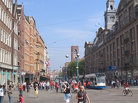
The Damrak is an avenue and partially filled in canal at the centre of Amsterdam, running between Amsterdam Centraal in the north and Dam Square in the south. It is the main street where people arriving at the station enter the centre of Amsterdam. Also it is one of the two GVB tram routes from the station into the centre, with lines 4, 9, 16, and 25 running down it. It is also on the route of the North/South Line (Amsterdam metro line) being constructed between the existing metro station at Centraal Station and the new Rokin station. The street was located on a rak (reach), a straight part of the Amstel river near a dam; hence the name. In the 19th century, a section of it was filled in. Because of the former stock exchange building, the monumental Beurs van Berlage, and several other buildings related to financial activities erected there in the early 20th century, the term "Damrak" has come to be a synonym for the Amsterdam Stock Exchange in the same way "Wall Street" is synonymous with the New York Stock Exchange and NASDAQ. The Beurs van Berlage now serves as a concert and exhibition hall. Today, the area is known for its restaurants, bars, and tourist shops. Its canals serve as a busy area for canal boats, as well.

Excerpt from the Wikipedia article Damrak (License: CC BY-SA 3.0, Authors, Images).

Damrak
Damrak, Amsterdam Centrum

Geographical coordinates (GPS) Address Nearby Places
placeShow on map

Wikipedia: DamrakContinue reading on Wikipedia

Geographical coordinates (GPS)

Latitude Longitude
N 52.376111111111 ° E 4.8972222222222 °
placeShow on map

Address

Pier 2

Damrak
1012 JN Amsterdam, Centrum
North Holland, Netherlands
mapOpen on Google Maps

Damrak
Damrak
Share experience

Nearby Places

Oudekerksplein
Oudekerksplein

The Oudekerksplein (English: Old Church's Square) is a square in the centre of Amsterdam. It is named after the 14th-century church Oude Kerk which dominates the square. The Oudekerksplein is wedged between the Warmoesstraat street and Oudezijds Voorburgwal canal. From the square, the Oudekerksbrug bridge crosses the Oudezijds Voorburgwal canal and continues eastwards, through the Oudekennissteeg and Molensteeg alleys, towards the Oudezijds Achterburgwal and Zeedijk. Originally the Oudekerksplein was a graveyard. In 1655, the graveyard was cleared and moved to a new location beyond the city limits, creating the present square. The Oudekerksplein lies at the heart of the red-light district of De Wallen. Along the square are some 35 windows from behind which prostitutes offer their services. As part of the so-called Project 1012 (first presented in 2007), the Amsterdam city government is trying to reduce the number of prostitutes on Oudekerksplein. The city wants to remove all brothels from the square and replace them with restaurants, shops, artists' workshops, and such. As part of the plans, the cannabis coffee shop on Oudekerksplein would also be closed. In March 2019, it was announced that the city is to ban guided tours of the red-light district from January 2020. There are reported to be over 1,000 such tours passing through Oudekerksplein each week.A statue titled "Belle", honouring the prostitutes of the world, was placed on the square in 2007. The plaque on this statue reads (in English): "Respect sex workers all over the world". The street also has a bronze relief of a hand caressing a female breast. The sculpture was set in the cobblestone in February 1993 by an anonymous artist. The 1968 Dutch documentary film Rondom het Oudekerksplein ("Around the Oudekerksplein") gave an impression of what life in the red-light district was like in the 1960s.