place

Sumner, New Zealand

Suburbs of ChristchurchUse New Zealand English from October 2021
Sumner 033
Sumner 033

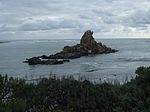
Sumner is a coastal seaside suburb of Christchurch, New Zealand and was surveyed and named in 1849 in honour of John Bird Sumner, the then newly appointed Archbishop of Canterbury and president of the Canterbury Association. Originally a separate borough, it was amalgamated with the city of Christchurch as communications improved and the economies of scale made small town boroughs uneconomic to operate.

Excerpt from the Wikipedia article Sumner, New Zealand (License: CC BY-SA 3.0, Authors, Images).

Sumner, New Zealand
Esplanade, Linwood-Central-Heathcote Community Sumner

Geographical coordinates (GPS) Address Nearby Places
placeShow on map

Wikipedia: Sumner, New ZealandContinue reading on Wikipedia

Geographical coordinates (GPS)

Latitude Longitude
N -43.57144 ° E 172.76447 °
placeShow on map

Address

Esplanade 96
8081 Linwood-Central-Heathcote Community, Sumner
Canterbury, New Zealand
mapOpen on Google Maps

Sumner 033
Sumner 033
Share experience

Nearby Places

Scarborough, New Zealand

Scarborough is a hillside suburb above Sumner in Christchurch, New Zealand. Scarborough is located between Sumner and Te Onepoto / Taylors Mistake. It was named for the seaside resort in North Yorkshire, England. The first European owner of most of the land was Major Alfred Hornbrook, whose Mount Pleasant run stretched as far east as Godley Head. A small land parcel of 25 acres (10 ha) near present-day Nicholson Park belonged to Charles Church Haslewood, who died in May 1858 when his hunting gun discharged while he looked down the barrel.The land was purchased by R. M. Morten, and after his death, his sons had Scarborough subdivided into 65 sections by July 1911. The first person who built in the area was Donald Patterson, a civil engineer. Patterson purchased all the land in the triangle formed by Scarborough Road and Flowers Track, and had it resurveyed into 41 sections, twice the number of the Morten brother survey.Nicholson Park has views from a number of vantage points in this 4 hectares (0.040 km2) location, with views of Sumner and the Canterbury coastline. Flowers Track can be descended from here, and it was the main start point of the walking track along the cliff tops that formed an early connection between Sumner and Taylors Mistake. The track went past Whitewash Head and Sumner Head; the former name was first recorded by Thomas Potts in his book Out in the Open in 1882 and it is presumed that it refers to the white appearance from shag droppings. The walkway was destroyed in the two earthquakes that hit on 13 June 2011; the first had its epicentre in Taylor's Mistake, and the second had its epicentre in Sumner. Much of the cliff faces collapsed into the sea below.Some of the land near the cliffs has been red zoned and purchased by the Canterbury Earthquake Recovery Authority. Houses on those properties are to be demolished, and the land is so unstable that drones are used to survey the land for establishing the best demolition method.

Richmond Hill, New Zealand

Richmond Hill is a hillside suburb above Sumner in Christchurch, New Zealand. Richmond Hill is a volcanic spur extending from Tauhinukorokio / Mount Pleasant. The first European owner was Edward Dobson, who had a cottage in Nayland Street and whose 50 acres (20 ha) ran up the hill. Dobson kept 2 acres (0.81 ha) around his house and sold the remainder of his land to George Day. Upon Day's death, the land passed to his daughter, who sold it to the Morton brothers (Arthur and R. M. D.), and who in turn sold it to George Humphreys. The latter subdivided the land and had a road up the hill built by 1909. Walter de Thier managed Humphreys' farm on the hill and his favourite song was "The Lass of Richmond Hill", and with Humphreys' consent, the property was called Richmond Hill.Humphreys was a leading businessman who lived at Daresbury in Fendalton. He was also a member of the Christchurch Golf Club and took pity of a group of men who regularly met in Sumner on an empty section for an improvised game of golf using hockey sticks, tennis balls, and tin cans sank into the ground as holes. He offered them 40 acres (16 ha) of his undulating land, on which the 12-hole Richmond Hill Golf Course opened in April 1910.Due to the steepness of the road up from Nayland Street, the subdivision was slow to develop. There were just ten houses on Richmond Hill by 1930, and activity only picked up after the end of World War II. One of the early residents included the architect Cecil Wood. The golf course closed in December 1997 and some of the land was further subdivided.

Taylors Mistake
Taylors Mistake

Te Onepoto / Taylors Mistake is a locality in New Zealand's South Island, at the southeastern extremity of the city of Christchurch Taylors Mistake is a bay adjacent to the locality, on the north side of Awaroa / Godley Head, on the northern edge of Banks Peninsula.The name Te Onepoto / Taylors Mistake is one of New Zealand's dual placenames. The Māori portion, Te Onepoto, means short or little beach. For the English portion, the Lyttelton Times in 1865 said it was "originally called Vincent's Bay, and more recently Taylors Mistake, owing to the master of a vessel running in here during the night-time, thinking he was about to pass over the Sumner Bar."There are almost 50 small century-old seaside baches remaining on the coastal strip between Hobsons Bay to the north, and Boulder Bay to the south. Some were cave baches, with Whare Moki being considered the oldest surviving example in NZ. Most of the baches were in 1995 or 2016 recognised as heritage assets by either Heritage NZ or by the Christchurch City Council under the resource management act. The baches appear in vernacular works of art and poetry, including a 1956 painting by Bill Sutton (artist) held at the Christchurch Art GalleryThe beach is popular with swimmers and surfers, and a livecam operated by some of the bach-holders allows conditions to be checked in advance. The Taylors Mistake Surf Life Saving Club was established at the beach, by bach-holders and others, in 1916. During World War II, hills above the beach were fortified with two machine gun posts, to guard the Godley Head coastal defence battery.

Clifton, Christchurch

Clifton is a hillside suburb above Sumner in Christchurch, New Zealand. Clifton is a volcanic spur extending from Tauhinukorokio / Mount Pleasant. Most of Clifton was originally purchased by Dr Alfred Barker, who had applied for a 50 acres (20 ha) land grant from the Christchurch land office. Barker sold his land in 1872. The lower part of Clifton was undeveloped until 1903, when it was subdivided into 93 sections and put up for auction, as far up the hill as Tuawera Terrace, which was originally known as Victoria Terrace. The land further up the hill was subdivided in 1908. A lower side spur, originally known as Lower Clifton, was bought in 1901 by Samuel Hurst Seager. Seager landscaped and divided the section into 12 plots and it was sold under the name The Spur in 1914. It has been known as the Spur since. This area is the main residential hill area above Sumner.The ridge that Clifton lies upon, descends from Tauhinukorokio / Mount Pleasant to end in a coastal cliff at the western end of Sumner beach. The cliff overhangs the road between Sumner and Moncks Bay that has been built along the beach. This area by the beach is now known as Peacocks Gallop because John Thomas Peacock would gallop his horse when riding along this section of road on account of his fear of being hit by falling rocks. Earthquakes in 2011 and later in 2016 caused the cliff edge to collapse and recede so much that several clifftop houses were undermined and severely damaged, or left perched precariously on the cliff edge. Shipping containers were stacked two-high on the main road below to protect it from further rockfalls and these subsequently became an impromptu roadside art gallery.