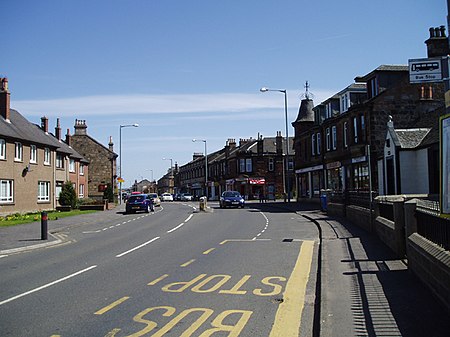
Larbert

Larbert (Scottish Gaelic: Leth-Pheairt, Scots: Lairbert) is a town in the Falkirk council area of Scotland. The town lies in the Forth Valley above the River Carron which flows from the west. Larbert is three miles (five kilometres) from the shoreline of the Firth of Forth and 2+1⁄2 miles (4 kilometres) northwest of Falkirk. Stenhousemuir lies directly east of Larbert, with both settlements being contiguous and sharing certain public amenities with one another.In medieval times, the Larbert area was heavily forested, but this was cleared and gave rise to much of the agricultural land which surrounds the town. The coming of industry and especially the arrival in the 1840s of the Scottish Central Railway, which passes through the village, provided a base for economic growth. From the late 18th century until the mid-20th century heavy industry, such as boilermaking, casting and manufacturing underpinned the economy of Larbert. The Victorian era also saw the opening of the Stirling District Lunatic Asylum at Bellsdyke and Scottish National Institution for Children on the Stenhouse Estate. This made Larbert central in providing care, both locally and nationally.Although the traditional economic base of Larbert dwindled with the decline of heavy industry, it has latterly experienced considerable growth as a commuter town. Many residents work in the nearby towns of Falkirk and Stirling, as well as the cities of Edinburgh and Glasgow. Scotland's Census of 2011 reveals that the population of Larbert has increased to 9,143 from the 2001 Census figure of 6,425 and it continues to grow with large-scale housing development on the northern periphery of the town as well as on brownfield sites.
Excerpt from the Wikipedia article Larbert (License: CC BY-SA 3.0, Authors, Images).Larbert
Carronvale Road,
Geographical coordinates (GPS) Address Nearby Places Show on map
Geographical coordinates (GPS)
| Latitude | Longitude |
|---|---|
| N 56.02291 ° | E -3.82602 ° |
Address
Carronvale Road
Carronvale Road
FK5 3LG , South Broomage
Scotland, United Kingdom
Open on Google Maps


