place

Camano Island State Park

1949 establishments in Washington (state)Parks in Island County, WashingtonProtected areas established in 1949State parks of Washington (state)Use mdy dates from August 2023
Camano Island beach 01

Camano Island State Park is a publicly owned recreation area on Camano Island in Puget Sound located 14 miles (23 km) southwest of Stanwood in Island County, Washington, United States. The park occupies 173 acres (70 ha) and has 6,700 feet (2,000 m) of shoreline. It is managed by the Washington State Parks and Recreation Commission.

Excerpt from the Wikipedia article Camano Island State Park (License: CC BY-SA 3.0, Authors, Images).

Camano Island State Park
Lowell Point Road,

Geographical coordinates (GPS) Address Phone number Website Nearby Places
placeShow on map

Wikipedia: Camano Island State ParkContinue reading on Wikipedia

Geographical coordinates (GPS)

Latitude Longitude
N 48.128611111111 ° E -122.49972222222 °
placeShow on map

Address

Camano Island State Park

Lowell Point Road 2269
98282
Washington, United States
mapOpen on Google Maps

Phone number
Washington State Parks and Recreation Commission

call+13603873031

Website
parks.state.wa.us

linkVisit website

Camano Island beach 01
Share experience

Nearby Places

Saratoga Passage
Saratoga Passage

Saratoga Passage lies in Puget Sound between Whidbey Island and Camano Island. Saratoga Passage extends about 18 miles in a northwesterly direction from its entrance between Sandy Point on the Whidbey Island side and Camano Head on the other. At its northern end, Saratoga Passage connects with Penn Cove and Crescent Harbor, and leads east into Skagit Bay. Depths in the passage are from about 600 feet at the southeastern entrance to about 90 feet near Crescent Harbor. Langley, Washington is the only city on either island located on the passage. Most of the waterfront on either side is high bank of forested sand and clay banks. There are four low bank communities on the Whidbey Island side of the passage: Sandy Point, Langley, Bells Beach and Fox Spit. The beaches are gravel and sand and the tide generally runs out a good distance. There is considerable maritime traffic in these waters, mostly recreational and fishing boats, with occasional tugs bound to or from Deception Pass or the Swinomish Channel. High-speed passenger ferries running between Seattle, Victoria and Friday Harbor use Saratoga Passage and Deception Pass as an alternative to crossing the Strait of Juan de Fuca in rough weather. This area is generally considered a resort area. Dungeness crab, clams and flatfish are abundant. In the past, strong salmon runs passed through on the way to the rivers on the mainland, but they have all but disappeared as have the once plentiful bait of candlefish and herring. Most of the fishing in southern end of Whidbey Island takes place on the western side, in Possession Sound, Mutiny Bay, or Double Bluff. Saratoga Passage was named by Charles Wilkes, during the Wilkes Expedition of 1838–1842, for the Saratoga, the flagship of Thomas MacDonough during the Battle of Lake Champlain of the War of 1812. Wilkes had named Camano Island MacDonough Island, to honor the naval commander, but that name was removed when Henry Kellett reorganized the official British Admiralty charts in 1847. Wilkes' name MacDonough was changed to Camano to honor the Spanish explorer Jacinto Caamaño. Wilkes' name Saratoga Passage was retained. George Vancouver had previously, in 1792, named Saratoga Passage "Port Gardner", in honor of Vice-Admiral Sir Alan Gardner. Today the name Port Gardner survives as the bay and harbor of Everett. Port Susan, the water east of Camano Island, also given by Vancouver, survives and honors Lady Gardner, Sir Alan's wife.

Greenbank, Washington

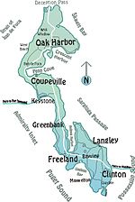
Greenbank is an unincorporated community on Whidbey Island in Island County, Washington, United States. Greenbank, which was named by Calvin Philips after his homestead in Delaware, has a population around 1626. It is the location of the Greenbank Farm, once the largest loganberry farm in the world, and the Greenbank Store, which was once owned and run by the Coupe family, descendants of Captain Thomas Coupe, founder of Coupeville and is now owned and run by new owners unrelated to the Coupe family. Opening in 1904, Greenbank Store features access to the post office and a small grocery store, as well as other amenities. Greenbank Farm, once the largest loganberry farm in the country, now has fields of trails and an off-leash dog area. The farm was saved from development when the Port of Coupeville agreed to purchase the 151-acre property and take on a 20-year bond payment in 1997. The purchase was completed in 2017 and continues to be operated by the Port of Coupeville. Greenbank Farm with its large historic, “Whidbey 1904 Barn” is a popular venue for weddings, social gatherings and seasonal markets. The Shops at Greenbank Farm, independent tenants of the Port of Coupeville, are located here as well. Behind the barns at the Greenbank Farm is a small marsh with a viewing platform recently built by the Whidbey Audubon Society. Many species of birds can be observed here including Red Wing Black-Birds and Warblers. Several solar projects have been implemented to reduce impact on the environment as well as offer free EV charging for all visitors. Greenbank is served by State Route 525, on which several places to stay and other businesses are located.