Tarbert, Kintyre

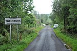
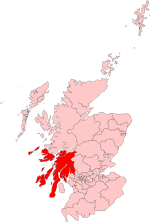
Tarbert (Scottish Gaelic: An Tairbeart, pronounced [ən̪ˠ ˈt̪ʰaɾʲapərˠʃt̪], or Tairbeart Loch Fìne to distinguish it from other places of the same name) is a village in the west of Scotland, in the Argyll and Bute council area. It is built around East Loch Tarbert, an inlet of Loch Fyne, and extends over the isthmus which links the peninsula of Kintyre to Knapdale and West Loch Tarbert. Tarbert had a recorded population of 1,338 in the 2001 Census. Tarbert has a long history both as a harbour and as a strategic point guarding access to Kintyre and the Inner Hebrides. The name Tarbert is the anglicised form of the Gaelic word tairbeart, which literally translates as "carrying across" and refers to the narrowest strip of land between two bodies of water over which goods or entire boats can be carried (portage). In past times cargoes were discharged from vessels berthed in one loch, hauled over the isthmus to the other loch, loaded onto vessels berthed there and shipped onward, allowing seafarers to avoid the sail around the Mull of Kintyre. Tarbert was anciently part of the Gaelic overkingdom of Dál Riata and protected by three castles – in the village centre, at the head of the West Loch, and on the south side of the East Loch. The ruin of the last of these castles, Tarbert Castle, still exists and dominates Tarbert's skyline. Around the year 1098 Magnus Barefoot, King of Norway, had his longship carried across the isthmus at Tarbert to signify his possession of the Western Isles. Despite its distinction as a strategic stronghold during the Middle Ages, Tarbert's socioeconomic prosperity came during the Early Modern period, as the port developed into a fishing town. At its height, the Loch Fyne herring fishery attracted hundreds of vessels to Tarbert.
Excerpt from the Wikipedia article Tarbert, Kintyre (License: CC BY-SA 3.0, Authors, Images).Tarbert, Kintyre
Campbeltown Road,
Geographical coordinates (GPS) Address Nearby Places Show on map
Geographical coordinates (GPS)
| Latitude | Longitude |
|---|---|
| N 55.863246 ° | E -5.415608 ° |
Address
Campbeltown Road
PA29 6TN
Scotland, United Kingdom
Open on Google Maps


