place

Burst Radio

EngvarB from September 2013Radio stations established in 1998Radio stations in BristolStudent radio in the United KingdomUniversity of Bristol
BurstPresenters2012
BurstPresenters2012

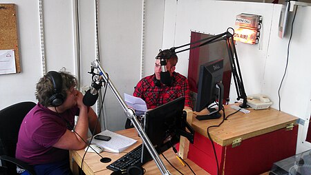
Bristol University's Radio Station (Burst) is a radio station run by students of the University of Bristol, UK. Its studios are located within the University of Bristol Students’ Union building and it broadcasts online. The station was initially known as ‘BURST FM’, but this name was dropped as the station no longer broadcasts on FM frequencies. The station is off air during university vacations.

Excerpt from the Wikipedia article Burst Radio (License: CC BY-SA 3.0, Authors, Images).

Burst Radio
Gordon Road, Bristol Clifton Village

Geographical coordinates (GPS) Address Website Nearby Places
placeShow on map

Wikipedia: Burst RadioContinue reading on Wikipedia

Geographical coordinates (GPS)

Latitude Longitude
N 51.456666666667 ° E -2.6130555555556 °
placeShow on map

Address

Bristol University Student Union

Gordon Road
BS8 1LN Bristol, Clifton Village
England, United Kingdom
mapOpen on Google Maps

Website
bristolsu.org.uk

linkVisit website

BurstPresenters2012
BurstPresenters2012
Share experience

Nearby Places

Whiteladies Road
Whiteladies Road

Whiteladies Road is a main road in Bristol, England. It runs north from the Victoria Rooms to Durdham Down, and separates Clifton on the west side from Redland and Cotham on the east. It forms part of the A4018. Significant buildings on Whiteladies Road include (from south to north): Broadcasting House, offices and studios of the British Broadcasting Corporation; the Whiteladies Picture House; Clifton Down railway station; Tyndale Baptist Church.Historically, the top half as far as Cotham Hill was the main easterly route into Bristol and the through route towards London and Bath from New Passage where there was a ferry from Wales. Later it was also the route into Bristol and onwards from the Port at Avonmouth. The road was extended in the early 1800s with the building of the second half of the street, and the route continued down Park Street. The main route from Avonmouth was superseded by the building of The Portway in the 1920s. Most of the traffic from Wales was removed after the building of the Severn Crossing and M4 in the 1960s, and traffic was further reduced later by the M32; however the modern A4018 still goes along much of the same route through Bristol, and now meets the M5 at Cribbs Causeway and is today still one of the important routes into west Bristol from the motorway. A shopping centre has been built around Clifton Down station, and to the north of the station Whiteladies Road has long been an important shopping area. The upper part of the road is commonly known as Blackboy Hill, named after the Black Boy Inn which stood on the hill until 1874. "Black Boy" was a common name for pubs after the Restoration. Charles II was commonly known as "the black boy" due to his black hair and the pub sign on Blackboy Hill had, until very recently, a portrait of Charles II on it. The origin of the name of Whiteladies Road appears to be a pub, known as the White Ladies Inn, shown on maps in 1746 and 1804. There is a popular belief in Bristol that the naming of both Whiteladies Road and Blackboy Hill had connections with the slave trade. However, both names appear to be derived from pubs. A map of 1826 shows a house called White Ladies, and the road at least as far as Whiteladies Gate (near the present site of Clifton Down station) had been given its name by that time. At that time the road north of Whiteladies Gate was a turnpike leading to New Passage.

Victoria Rooms, Bristol

The Victoria Rooms, also known as the Vic Rooms, houses the University of Bristol's music department in Clifton, Bristol, England, on a prominent site at the junction of Queens Road and Whiteladies Road. The building, originally assembly rooms, was designed by Charles Dyer and was constructed between 1838 and 1842 in Greek revival style, and named in honour of Queen Victoria, who had acceded to the throne in the previous year. An eight column Corinthian portico surmounts the entrance, with a classical relief sculpture designed by Musgrave Watson above. The construction is of dressed stonework, with a slate roof. A bronze statue of Edward VII, was erected in 1912 at the front of the Victoria Rooms, together with a curved pool and several fountains with sculptures in the Art Nouveau style. The Victoria Rooms contain a 665-seat auditorium, a lecture theatre, recital rooms, rehearsal rooms and a recording studio. Jenny Lind and Charles Dickens performed at the Victoria Rooms. It was also the venue for important dinners and assemblies, including banquets to commemorate the opening of the Clifton Suspension Bridge and the quatercentennial anniversary of Cabot's discovery of North America, meetings which led to the establishment of the University College, Bristol, an early congress of the British Association for the Advancement of Science and suffragettes "at-homes". The building was purchased and given to the university in 1920 as a home for the student union and, circa 1924, it spent a brief period as a cinema. Following a fire in 1934, the building was refurbished by the university. It remained as the base of the student union until purpose built facilities were opened in Queens Road in the 1960s. The Victoria Rooms then became an exhibition and conference centre, before housing the music department in 1996. They remain in use in the 21st century for concerts, exhibitions, plays, recitals and lectures.

Jews Acre, Bristol
Jews Acre, Bristol

The Jews Acre (alias Jews Churchyard) in Cliftonwood, Bristol, England was the burial ground of Bristol's medieval Jewish community from the late 12th century until the expulsion of the Jews from England in 1290. Bristol's jews lived a mile east in the centre of the town, initially around the head of the harbour - an area that was later known as the Old Jewry. It was one of England's smaller Jewish communities, never exceeding about fifteen households. If the average household had five people, the mean population would have been about seventy-five people. Life expectancy at birth in pre-modern societies rarely exceed forty, with at least 2.5 per cent of any community dying each year. That would imply about two internments per year in the cemetery. Jews Acre is associated with Jacob's Well, which lies about a hundred metres further down the valley. The well is believed to have been a bet tohorah (ritual bath) where corpses were washed prior to internment in the cemetery. After a body had been buried, those involved would also have used the water from the well to ritually purify themselves. The Jews Acre, sometimes called the Jews Churchyard, was known by that name until 1847, when the site was purchased by Queen Elizabeth's Hospital (also known as 'QEH'), an independent school in Bristol. Founded in 1586, the school had previously been based in the centre of the city, but decided to move to a new, greener site, on the edge of Clifton. The property known as Jews Acre became the boundary of the school. Despite its name, the actual field was 3.2 acres in size (1.3 hectares). Apart from two small additions (QEH Theatre) and a southern annex, both acquired in the later twentieth century, the school's boundary is still that of the Jews Acre.During the construction of QEH school from 1847, a number of tombstones were found. Writing in 1861, the historian George Pryce discussed 'the “Jews Acre”, or burial ground, where now stands Queen Elizabeth's Hospital, on digging the foundation for which, a few years ago, a number of gravestones were found, with inscriptions in Hebrew characters; they were, however, thoughtlessly used in the building' This became a source of humour in Victorian Bristol, it later being noted that 'Many gravestones with Hebrew inscriptions were discovered when that building [QEH] was about to be erected, which led our Wits to assert that whatever else the boys lacked, they would always have a good Hebrew foundation.'
Queen Elizabeth's Hospital

Queen Elizabeth's Hospital (also known as QEH) is an independent day school in Clifton, Bristol, England, founded in 1586. QEH is named after its original patron, Queen Elizabeth I. Known traditionally as "The City School", Queen Elizabeth's Hospital was founded by the will of affluent soap merchant John Carr in 1586, gaining its first royal charter in 1590. The school accepts boys from ages 7 to 18 and, since September 2017, girls aged 16 to 18 into the co-educational Sixth Form. The school began as a boarding school, accepting 'day boys' for the first time in the early 1920s. Boarders continued to wear the traditional blue coat uniform on a daily basis until the 1980s. After that, it was only worn on special occasions. Following a steady decline in numbers QEH stopped accepting new boarders in 2004, and boarding closed completely in July 2008. A Junior School opened in September 2007 in terraced Georgian town houses in Upper Berkeley Place, adjacent to the main school.The school is located in central Bristol, near Cabot Tower which is on Brandon Hill, in a building built of Brandon stone, designed by local architects Foster and Son and dating from 1847. It has been designated by English Heritage as a grade II listed building. The terrace steps and walls are also grade II listed, as are the walls, lodge and gates. Before moving to the site on Brandon Hill, it was previously housed at Gaunt's Hospital mansion house, Unity Street (1590–1767) and St. Bartholomew's, Christmas Steps (1767–1847). QEH has had close associations with Redmaids' High School since the latter's founding in 1634.To celebrate 425 years since the school's opening, a new school song was composed in 2015.