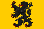
The County of Flanders was one of the most powerful political entities in the medieval Low Countries, located on the North Sea coast of what is now Belgium. Unlike its neighbours such as the counties of Brabant and Hainaut, it was within the territory of the Kingdom of France. The counts of Flanders held the most northerly part of the kingdom, and were among the original twelve peers of France. For centuries, the economic activity of the Flemish cities such as Ghent, Bruges and Ypres made Flanders one of the most affluent regions in Europe, and also gave them strong international connections to trading partners.
Up to 1477, the core area under French suzerainty was west of the Scheldt and was called "Royal Flanders" (Dutch: Kroon-Vlaanderen, French: Flandre royale). Aside from this, the counts, from the 11th century onward, held land east of the river as a fief of the Holy Roman Empire: "Imperial Flanders" (Rijks-Vlaanderen or Flandre impériale). The county joined its Low Country neighbours within the Burgundian Netherlands from 1384, which eventually complicated its relationship with France. Most of the county became part of the Empire after the Peace of Madrid in 1526 and the Peace of the Ladies in 1529.
Having already regained much, by 1795, the rest – within the Austrian Netherlands – was acquired likewise by France under the French First Republic, recognized by treaty in 1797. Resulting from the Battle of Waterloo of the same year, it passed to the newly established United Kingdom of the Netherlands in 1815. The former County of Flanders, except for French Flanders, is the only part of the late medieval French kingdom outside of modern-day France (Catalonia having been renounced in 1258).


