Pumicestone Channel
CaloundraChannels of AustraliaCommons category link is locally definedImportant Bird Areas of QueenslandMoreton Bay ... and 1 more
Use Australian English from June 2020

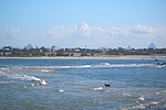
Pumicestone Channel, also known as the Pumicestone Passage, is a narrow, mesotidal waterway around 45 kilometres in length, between Bribie Island and the mainland in Queensland, Australia. The northern extent of the passage is at Caloundra, while at the south is Deception Bay. The waterway is a two way tidal estuary that has 11 creeks flowing into it. At each end of the passage the channels are the deepest and widest.During periods of unusually high tides and large waves, the passage is infiltrated by inflows through channels in dunes at the northern tip of Bribie Island.
Excerpt from the Wikipedia article Pumicestone Channel (License: CC BY-SA 3.0, Authors, Images).Pumicestone Channel
Sunshine Coast Regional
Geographical coordinates (GPS) Address Nearby Places Show on map
 Continue reading on Wikipedia
 Geographical coordinates (GPS)
| Latitude | Longitude |
|---|---|
| N -26.9394 ° | E 153.0698 ° |
Address
Beerburrum
Sunshine Coast Regional (Beerburrum)
Queensland, Australia
Open on Google Maps