Des Allemands, Louisiana
Census-designated places in Houma – Thibodaux metropolitan areaCensus-designated places in Lafourche Parish, LouisianaCensus-designated places in LouisianaCensus-designated places in St. Charles Parish, LouisianaCensus-designated places in the New Orleans metropolitan area ... and 3 more
German-American culture in LouisianaGerman-American historyUse mdy dates from July 2023

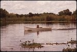
Des Allemands is an unincorporated community and census-designated place (CDP) in Lafourche and St. Charles parishes in the southeastern part of the U.S. state of Louisiana. The population was 2,179 at the 2020 census. The town, known as the "Catfish Capital of the Universe", is along the Bayou des Allemands, which is the boundary of Lafourche and St. Charles parishes. Lac des Allemands is located northwest of the town. The ZIP Code for Des Allemands is 70030. The St. Charles Parish portion of Des Allemands is part of the New Orleans metropolitan statistical area, while the Lafourche Parish portion is part of the Houma–Bayou Cane–Thibodaux metropolitan statistical area.
Excerpt from the Wikipedia article Des Allemands, Louisiana (License: CC BY-SA 3.0, Authors, Images).Des Allemands, Louisiana
Highway 631,
Geographical coordinates (GPS) Address Nearby Places Show on map
 Continue reading on Wikipedia
 Geographical coordinates (GPS)
| Latitude | Longitude |
|---|---|
| N 29.825555555556 ° | E -90.469166666667 ° |
Address
Highway 631
70030
Louisiana, United States
Open on Google Maps