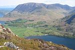
Grasmoor
Buttermere, Cumbria (village)Fells of the Lake DistrictHewitts of EnglandMarilyns of EnglandNuttalls

Grasmoor is a mountain in the north-western part of the Lake District, northern England. It is the highest peak in a group of hills between the villages of Lorton, Braithwaite and Buttermere, and overlooks Crummock Water. Grasmoor is distinguished by its steep western flank, dropping dramatically to Crummock Water. This face is however not suitable for rock climbers as there is little clean rock, although Alfred Wainwright describes a challenging route up the face in his Pictorial Guides to the Lakeland Fells. To the east the fell is linked to others by Crag Hill and Coledale Hause. Grasmoor is also home to the most extensive scree slopes in the North Western Fells.
Excerpt from the Wikipedia article Grasmoor (License: CC BY-SA 3.0, Authors, Images).Grasmoor
B5289,
Geographical coordinates (GPS) Address Nearby Places Show on map
Geographical coordinates (GPS)
| Latitude | Longitude |
|---|---|
| N 54.57115 ° | E -3.27918 ° |
Address
B5289
CA13 9UY
England, United Kingdom
Open on Google Maps


