Fort Garry

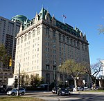
Fort Garry, also known as Upper Fort Garry, was a Hudson's Bay Company trading post at the confluence of the Red and Assiniboine rivers in what is now downtown Winnipeg. Fort Garry was established in 1822, although its first iteration was destroyed in 1826 by severe flooding. The trading post was rebuilt in 1836 and served as the administrative centre for the Red River Colony. From 1869 to 1870, the fort was briefly occupied by Louis Riel and his Métis followers during the Red River Rebellion. The fort was demolished in the 1880s to make way for Winnipeg's Main Street, although the fort's gate remains. The site of the former fort was designated as a part of a larger National Historic Site in 1924. Development of a provincial heritage site on the historic site of Fort Garry began in the early 21st century.
Excerpt from the Wikipedia article Fort Garry (License: CC BY-SA 3.0, Authors, Images).Fort Garry
Main Street, Winnipeg Fort Rouge–East Fort Garry
Geographical coordinates (GPS) Address Website External links Nearby Places Show on map
 Continue reading on Wikipedia
 Geographical coordinates (GPS)
| Latitude | Longitude |
|---|---|
| N 49.887883 ° | E -97.13532 ° |
Address
Upper Fort Garry Provincial Heritage Park
Main Street 100
R3C 1A3 Winnipeg, Fort Rouge–East Fort Garry
Manitoba, Canada
Open on Google Maps
Website
upperfortgarry.com
External links