Longships Lighthouse
Commons category link is locally definedLighthouses completed in 1795Lighthouses completed in 1875Lighthouses in CornwallSennen ... and 1 more
Use British English from May 2017

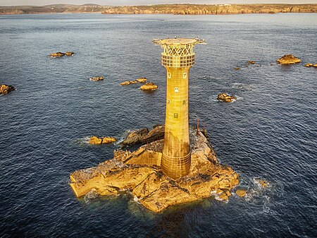
Longships Lighthouse is an active 19th-century lighthouse about 1.25 mi (2.0 km) off the coast of Land's End in Cornwall, England. It is the second lighthouse to be built on Carn Bras, the highest of the Longships islets which rises 39 feet (12 m) above high water level. In 1988 the lighthouse was automated, and the keepers withdrawn. It is now remotely monitored from the Trinity House Operations & Planning Centre in Harwich, Essex.
Excerpt from the Wikipedia article Longships Lighthouse (License: CC BY-SA 3.0, Authors, Images).Longships Lighthouse
The Cornish Way,
Geographical coordinates (GPS) Address External links Nearby Places Show on map
Geographical coordinates (GPS)
| Latitude | Longitude |
|---|---|
| N 50.066858333333 ° | E -5.746775 ° |
Address
Longships
The Cornish Way
TR19 7AF
England, United Kingdom
Open on Google Maps


