Mount Batten

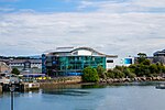
Mount Batten is a 24-metre (80-ft) tall outcrop of rock on a 600-metre (2000-ft) peninsula in Plymouth Sound, Devon, England, named after Sir William Batten (c.1600-1667), MP and Surveyor of the Navy; it was previously known as How Stert.After some redevelopment which started with the area coming under the control of the Plymouth Development Corporation for five years from 1993, the peninsula now has a marina and centre for sea sport. The Mount Batten Breakwater (also referred to as Cattewater Breakwater and, incorrectly, Mount Batten Pier) to the west doubles as a breakwater for the Cattewater and Sutton Harbour. It was built in 1881 by the Cattewater Commissioners and subsequently refurbished by the Plymouth Development Corporation opening formally in 1995. The unveiling of the plaque by opening of a temporary curtain during the 1995 re-opening ceremony was done so by Tim Fulfit (age 10 at the time) who was a pupil selected from the local Hooe Primary School.
Excerpt from the Wikipedia article Mount Batten (License: CC BY-SA 3.0, Authors, Images).Mount Batten
Lawrence Road, Plymouth Barbican
Geographical coordinates (GPS) Address Nearby Places Show on map
Geographical coordinates (GPS)
| Latitude | Longitude |
|---|---|
| N 50.359444444444 ° | E -4.1297222222222 ° |
Address
Lawrence Road
PL9 9SJ Plymouth, Barbican
England, United Kingdom
Open on Google Maps


