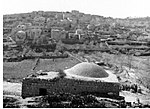
Jimzu
Arab villages depopulated during the 1948 Arab–Israeli WarDistrict of RamlaPages with non-numeric formatnum argumentsPhilistines

Jimzu (Arabic: جمزو), also known as Gimzo (meaning "sycamore plantation"), was a Palestinian village, located three miles southeast of Lydda. Under the 1947 UN Partition Plan of Mandatory Palestine, Jimzu was to form part of the proposed Arab state. During the 1948 Arab–Israeli War, the village was depopulated in a two-day assault by Israeli forces. Under the 1949 Armistice Agreements, Jimzu's lands fell under the de facto governance of the newly created state of Israel. A year later, moshav Gimzo was established at the site of the former village and is now populated by 700 Israeli Jewish residents.
Excerpt from the Wikipedia article Jimzu (License: CC BY-SA 3.0, Authors, Images).Jimzu
יוגוסלביה, Hevel Modiin Regional Council
Geographical coordinates (GPS) Address Nearby Places Show on map
Geographical coordinates (GPS)
| Latitude | Longitude |
|---|---|
| N 31.930833333333 ° | E 34.946388888889 ° |
Address
מצפה השניים
יוגוסלביה
Hevel Modiin Regional Council
Center District, Israel
Open on Google Maps


