place

St. Matthew's Anglican Church (Ottawa)

1898 establishments in Ontario20th-century Anglican church buildings in CanadaAnglican church buildings in OttawaCultural infrastructure completed in 1930Gothic Revival architecture in Ottawa
Gothic Revival church buildings in CanadaSource attribution
St Matthews Ottawa
St Matthews Ottawa

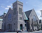
St. Matthew's Anglican Church is an Anglican church in the Glebe neighbourhood of Ottawa, Ontario, Canada. Founded in 1898 to serve the growing area it is the fifth oldest Anglican parish in central Ottawa after St. Alban's, St. Bartholomew's, Trinity, and Ascension. It is a registered charity # 108084658RR0078 providing spiritual worship, spiritual guidance, pastoral care, and community outreach.

Excerpt from the Wikipedia article St. Matthew's Anglican Church (Ottawa) (License: CC BY-SA 3.0, Authors, Images).

St. Matthew's Anglican Church (Ottawa)
First Avenue, (Old) Ottawa Capital

Geographical coordinates (GPS) Address Phone number Website External links Nearby Places
placeShow on map

Wikipedia: St. Matthew's Anglican Church (Ottawa)Continue reading on Wikipedia

Geographical coordinates (GPS)

Latitude Longitude
N 45.404385 ° E -75.6902 °
placeShow on map

Address

St. Matthew's

First Avenue 217
K1S 2G5 (Old) Ottawa, Capital
Ontario, Canada
mapOpen on Google Maps

Phone number

call+16132344024

Website
stmatthewsottawa.ca

linkVisit website

linkWikiData (Q7590584)
linkOpenStreetMap (68661139)

St Matthews Ottawa
St Matthews Ottawa
Share experience

Nearby Places

The Glebe
The Glebe

The Glebe is a neighbourhood in Ottawa, Ontario, Canada. It is located just south of Ottawa's downtown area in the Capital Ward. According to the Glebe Community Association, the neighbourhood is bounded on the north by the Queensway, on the east and south by the Rideau Canal and on the west by LeBreton Street South, Carling Avenue and Dow's Lake. As of 2016, this area had a population of 13,055. This area includes the Glebe Annex, an area west of Bronson Avenue, north of Carling Avenue, east of LeBreton South Street and south of the Queensway, that maintains its own neighbourhood association - the Glebe Annex Community Association (GACA). The Glebe also includes the Dow's Lake neighbourhood, an area north of the Rideau Canal, east of Dow's Lake, south of Carling Avenue and west of Bronson, that maintains its own neighbourhood association - the Dow's Lake Residents Association (DLRA). The Glebe has a strong community association which, in addition to running a large community centre, lobbies the local government on issues such as traffic calming and neighbourhood development. The Glebe has a community newspaper, Glebe Report, that has been published independently since 1973. The Glebe is mostly populated by families; the area has many children, and consequently its social services are oriented towards youth. The Glebe lies in the federal riding of Ottawa Centre, and the same provincial electoral district. The stretch of Bank Street that runs through the Glebe is one of Ottawa's premier shopping areas, with many small stores and restaurants offering a wide variety of services. Much of the rest of the Glebe consists of detached homes, many of them constructed in the early decades of the 20th century. Some of these homes are owner-occupied family residences, while others have been subdivided into multiple rental apartments. The Glebe is home to Lansdowne Park which contains TD Place Stadium, where Ottawa's Canadian Football League (CFL) football team (the Ottawa Redblacks) and the University of Ottawa Gee-Gees play their home games. Lansdowne Park also contains TD Place Arena, which is the permanent home of the Ottawa 67's and was the temporary home (1992–1995) for the Ottawa Senators before the Canadian Tire Centre (originally called The Palladium) was completed. The area that became the park was purchased from local farmers in 1868 by the City of Ottawa Agricultural Society. From the Rideau Canal, two bodies of water jut into the Glebe: Patterson Creek and Brown's Inlet. These areas are surrounded by parks and some of the city's most expensive homes. The last Saturday in May of each year brings the "Great Glebe Garage Sale" to the neighbourhood; every household that participates puts items out for sale, attracting a large contingent of bargain hunters to the area. Sellers are expected to donate a portion of the proceeds to a designated charity. May is also the time of the national capital's Tulip Festival. The largest tulip beds in the National Capital Region are found in Commissioner's Park in the Dow's Lake neighbourhood, next to Dow's Lake.

Ottawa Central Station

Ottawa Central Station was the main inter-city bus station in Ottawa, Ontario, Canada. It was located 1.5 km south of downtown Ottawa in the Centretown neighbourhood and served buses from Greyhound Canada, Ontario Northland and Autobus Gatineau. It closed on June 1, 2021, and the land it sat on is now owned by Brigil, a real estate developer, who plans to build a multi-use space for housing, dining, retail, and other businesses.Ottawa Central Station was located at 265 Catherine Street, between Lyon Street and Kent Street. Catherine Street lies directly north of Ontario Highway 417 (known locally as the Queensway), which is the main expressway through Ottawa. The former station was accessible from highway 417 exits 120 (eastbound) and 119 (westbound). The station's main entrance faced south towards Catherine Street and the 417. On the north side of the station building, buses called at 14 outdoor bus stands with adjoining indoor gates. The front of the buses were partially covered by a roof overhang. The property it sat on is located one block west of Bank Street, a major north-south commercial street in Ottawa. Continuing north on Bank Street leads to downtown and the main government and business district, while south of highway 417, the street passes through the more residential neighbourhood of the Glebe on its way to Landsdowne Park and the Rideau Canal. Nearby landmarks include the Canadian Museum of Nature on Metcalfe Street and beyond that, the southern end of Elgin Street, a north-south commercial street with many small shops, restaurants and bars. Ottawa Central Station was located roughly 5 kilometres (3.1 mi) west of the Ottawa Train Station and 11 kilometres (6.8 mi) north of Ottawa Macdonald–Cartier International Airport.