place

McLaren Vale

Geography of AdelaideUse Australian English from September 2014Wine regions of South Australia
McLaren Vale
McLaren Vale

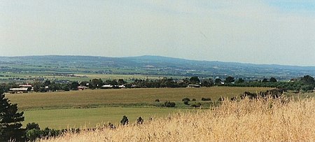
McLaren Vale is a wine region in the Australian state of South Australia located in the Adelaide metropolitan area and centred on the town of McLaren Vale about 38 kilometres (24 mi) south of the Adelaide city centre. It is internationally renowned for the wines it produces and is included within the Great Wine Capitals of the World. The region was named after either David McLaren, the Colonial Manager of the South Australia Company or John McLaren (unrelated) who surveyed the area in 1839. Among the first settlers to the region in late 1839, were two English farmers from Devon, William Colton and Charles Thomas Hewett. William Colton established the Daringa Farm and Charles Thomas Hewett established Oxenberry Farm. Both men would be prominent in the early days of McLaren Vale. Although initially the region's main economic activity was the growing of cereal crops, John Reynell and Thomas Hardy planted grape vines in 1838 and the present-day Seaview and Hardy wineries were in operation as early as 1850. Grapes were first planted in the region in 1838 and some vines more than 100 years old are still producing.

Excerpt from the Wikipedia article McLaren Vale (License: CC BY-SA 3.0, Authors, Images).

McLaren Vale
Tatachilla Road, Adelaide

Geographical coordinates (GPS) Address Nearby Places
placeShow on map

Wikipedia: McLaren ValeContinue reading on Wikipedia

Geographical coordinates (GPS)

Latitude Longitude
N -35.219437 ° E 138.543615 °
placeShow on map

Address

Tatachilla Road

Tatachilla Road
5171 Adelaide
South Australia, Australia
mapOpen on Google Maps

McLaren Vale
McLaren Vale
Share experience

Nearby Places

Electoral district of Mawson

Mawson is a single-member electoral district for the South Australian House of Assembly. It covers the entirety of Kangaroo Island, and parts of the local government areas of Alexandrina Council, the City of Onkaparinga, and the District Council of Yankalilla. Major localities in the district include Cape Jervis, Kingscote, McLaren Vale, Port Willunga, Sellicks Beach, Willunga and Yankalilla. The electorate was created in the 1969 redistribution, taking effect at the 1970 election. It is named after Sir Douglas Mawson, a geologist and explorer who made several expeditions to Antarctica. For the first three decades of its existence, it was a bellwether seat held by the party of government. This pattern was broken at the 2002 election, when Robert Brokenshire held the seat for the Liberals amidst a Labor election victory. Although it was thought that Brokenshire had established a base in Mawson, it reverted to form at the 2006 election, when Labor candidate and former journalist Leon Bignell won amid that year's massive Labor landslide. Bignell went on to increase his seat margins at the 2010 and 2014 elections. In both cases, he not only bucked the statewide trend, but also decades of voting patterns in the electorate. The 2016 redistribution ahead of the 2018 election heavily redistributed Mawson from a 5.6 percent Labor seat to a notional 3.2 percent Liberal seat, taking in areas down the coast as far as and including Kangaroo Island. However, Bignell picked up a swing of over four percent to narrowly retain the seat even as Labor lost government; he thus became its second opposition member. In 2022, Bignell achieved a big swing of over 15% to win the primary vote with over 51% and a 13% swing on the two-party preferred margin giving it a 63% Two-Party Preferred margin making it a safe Labor seat.