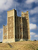
Orford Ness
Beaches of SuffolkEngvarB from June 2017Landforms of SuffolkNational Trust properties in SuffolkNature Conservation Review sites ... and 4 more
Orford, SuffolkOrford NessSpits of EnglandTourist attractions in Suffolk

Orford Ness is a cuspate foreland shingle spit on the Suffolk coast in Great Britain, linked to the mainland at Aldeburgh and stretching along the coast to Orford and down to North Weir Point, opposite Shingle Street. It is divided from the mainland by the River Alde, and was formed by longshore drift along the coast. The material of the spit comes from places further north, such as Dunwich. Near the middle point of its length, at the foreland point or 'Ness', once stood Orfordness Lighthouse, demolished in summer 2020 owing to the encroaching sea. In the name of the lighthouse (and the radio transmitting station – see below), 'Orfordness' is written as one word.
Excerpt from the Wikipedia article Orford Ness (License: CC BY-SA 3.0, Authors, Images).Orford Ness
Doctor's Lane, East Suffolk
Geographical coordinates (GPS) Address Phone number Website Nearby Places Show on map
Geographical coordinates (GPS)
| Latitude | Longitude |
|---|---|
| N 52.081388888889 ° | E 1.5586111111111 ° |
Address
Orford Ness National Nature Reserve (National Trust)
Doctor's Lane
IP12 2QJ East Suffolk
England, United Kingdom
Open on Google Maps


