Charleton
Civil parishes in South HamsDevon geography stubs

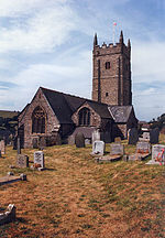
Charleton is a civil parish in the South Hams district, in the county of Devon, England. In 2001 its population was 511. The parish forms part of the Saltstone electoral ward. At the 2011 census the ward had a population of 1,529.Its main settlements are East Charleton (a hamlet) and West Charleton which has the parish church of St Mary's, (the latter being the larger of the two settlements).
Excerpt from the Wikipedia article Charleton (License: CC BY-SA 3.0, Authors, Images).Charleton
A379, South Hams Charleton
Geographical coordinates (GPS) Address Nearby Places Show on map
Geographical coordinates (GPS)
| Latitude | Longitude |
|---|---|
| N 50.270277777778 ° | E -3.7419444444444 ° |
Address
A379
TQ7 2BP South Hams, Charleton
England, United Kingdom
Open on Google Maps


