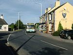
High Coniscliffe

High Coniscliffe is a parish and village in the borough of Darlington and ceremonial county of County Durham, England. The parish includes Carlbury and Low Coniscliffe. It is part of Heighington and Coniscliffe ward, and is situated approximately 4 miles (6.4 km) west of Darlington. At the 2011 Census the population of this civil parish was 242.It is now a linear village, with most houses along the north side of the A67, but is also a doubly nucleated village as it has a village green and church on the south side of the road, and a history of a community focus at the T-junction of Ulnaby Lane and the A67, where the Methodist church and post office once were, and where a public house remains. It has always been a small village, but its history goes back to Anglo-Saxon times, and the earliest part of St Oswald's church is Norman. The Duke of Wellington pub is notable for having had a portrait of Napoleon, Wellington's defeated enemy, on its sign from 1975 to 1988.
Excerpt from the Wikipedia article High Coniscliffe (License: CC BY-SA 3.0, Authors, Images).High Coniscliffe
Mill Lane,
Geographical coordinates (GPS) Address Nearby Places Show on map
Geographical coordinates (GPS)
| Latitude | Longitude |
|---|---|
| N 54.53684 ° | E -1.64777 ° |
Address
Mill Lane
Mill Lane
DL2 2LH , High Coniscliffe
England, United Kingdom
Open on Google Maps


