place

Massachusetts College of Liberal Arts

1894 establishments in MassachusettsBuildings and structures in North Adams, MassachusettsEducational institutions established in 1894Liberal arts colleges in MassachusettsMassachusetts College of Liberal Arts
Public liberal arts colleges in the United StatesPublic universities and colleges in MassachusettsUniversities and colleges in Berkshire County, Massachusetts

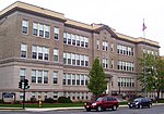
The Massachusetts College of Liberal Arts (MCLA) formerly known as North Adams State College (NASC) is a public liberal arts college in North Adams, Massachusetts. It is part of the state university system of Massachusetts. It is a member of the Council of Public Liberal Arts Colleges. Originally established as part of the state's normal school system for training teachers, it now offers programs leading to Bachelor of Science and Bachelor of Arts degrees, as well as a Master of Education track.

Excerpt from the Wikipedia article Massachusetts College of Liberal Arts (License: CC BY-SA 3.0, Authors).

Massachusetts College of Liberal Arts
Church Street,

Geographical coordinates (GPS) Address Phone number Website External links Nearby Places
placeShow on map

Wikipedia: Massachusetts College of Liberal ArtsContinue reading on Wikipedia

Geographical coordinates (GPS)

Latitude Longitude
N 42.6917 ° E -73.1039 °
placeShow on map

Address

Massachusetts College of Liberal Arts

Church Street 375
01247
Massachusetts, United States
mapOpen on Google Maps

Phone number

call+1(413)6625000

Website
mcla.edu

linkVisit website

linkWikiData (Q6784220)
linkOpenStreetMap (225312235)

Share experience

Nearby Places

Normal School Historic District

The Normal School Historic District is a historic district in North Adams, Massachusetts. It consists of a group of ten buildings located along Church Street, roughly from Bradley Street in the south to Murdock Hall on the campus of the Massachusetts College of Liberal Arts (MCLA) in the north. The buildings represent a period of cohesive development of the area in the late 19th and early 20th centuries, shortly after the normal school (later North Adams State College, then MCLA) was established. It includes nine houses, eight of which are private residences, and one institutional building, Murdock Hall, dating to the inception of the normal school. The tenth building is Smith House, originally known as the Principal's House (later President's House), which is next door to Murdock Hall on the MCLA campus. All of the residential properties, including Smith House, are large Victorian houses. Six are in the Queen Anne style, with porches and turreted sections, while three are in the Colonial Revival style. Murdock Hall was built in 1896 (as was Smith House) and served as the normal school's main building. It is a rectangular Italianate structure built of yellow brick designed by architect H. Neill Wilson, and features a central pilaster-supported triangular pediment. Smith House is built of the same materials, but with Colonial Revival styling. A dormitory built at the same time has not survived.South of Smith House on the west side of Church Street are three private residences, all built in either 1896 or 1897. The first of these, the Queen Anne style Hawkins House, was built according to a mail-order plan, and features some of the most elaborate woodwork in North Adams. The other five private residences are situated on the east side of Church Street; all but one was built in the early 1890s, before the normal school was established.The district was listed on the National Register of Historic Places in 1985.

H. W. Clark Biscuit Company

The H. W. Clark Biscuit Company is a former industrial complex in North Adams, Massachusetts. The bakery that Herbert W. Clark built at this site began at a facility on Liberty Street, and expanded into a shoe factory building (demolished in 1929) that Clark had operated with a partner. When the Liberty Street plant was destroyed by fire in 1913, Clark placed its employees on a second shift in the shoe factory building, and had the building now called the Icing Building constructed. This building was built in a style reminiscent of mills built in North Adams fifty years earlier, and is still sometimes thought to be an older building.In addition to the Icing Building, Clark in 1913 built a Boiler House, which was attached to a warehouse formerly associated with the shoe business (and is the oldest surviving building on the property, dating to 1884). In 1922 Clark embarked on an ambitious modernization of the facility, constructing the Baking Building out of reinforced concrete to a design by New York architect William Higginson. It was the first reinforced concrete building in the city.Clark sold the business in 1928 after his health began to fail. His successors operated the bakery until 1954. The buildings underwent a series of ownership changes, but were used for nearly forty years by the Tartan Machine Company. That business vacated the premises in 1990. After being vacant for two decades, the property was rehabilitated and converted to residential use. The complex was added to the National Register of Historic Places in 2009.

Church Street–Cady Hill Historic District

The Church Street–Cady Hill Historic District, originally known as the Church Street Historic District, is a historic district in North Adams, Massachusetts. It was first listed on the National Register of Historic Places in 1983 and was expanded and renamed in 1985. The district encompasses the principal residential areas near the center of downtown. When first designated it included residences primarily on East Main Street and Church Street, as well as properties in the neighborhood south of East Main and east of Church; the 1985 expansion extended the district further east and west, to properties on Ashland Street and streets connecting it to Church Street to the west, and the properties along Pleasant Street, Cherry Street, and adjacent streets to the east of Church Street.Church Street, the area's principal route, was laid out about 1780, and is one of the city's oldest roads. Residential development in the area remained modest until the 1850s, and in the subsequent decades a significant number of Italianate and Second Empire houses were built on Church Street and adjacent side streets, which were laid out beginning in the 1840s. Later development extended further from Church Street, with a fine assembly of Stick and Queen Anne style houses on Holbrook and Cherry Streets to the east. Most of these houses were not designed by architects; one (27 Wall Street) is based on a pattern published by Palliser, Palliser & Company in one of its architectural design books.

Monument Square–Eagle Street Historic District

The Monument Square–Eagle Street Historic District is a historic district encompassing the civic heart of North Adams, Massachusetts. When it was originally designated in 1972, the district encompassed Monument Square – west of the intersection of Main Street and Church Street, and the location of a Civil War memorial – and the area around it. This designation included the North Adams Public Library (formerly the Blackinton Mansion), the First Baptist Church and First Congregational Church, and a block of shops Eagle Street. In 1988, the district's boundaries were increased to be roughly bounded by Holden, Center and Union Streets, the East Middle School (now the Silvio O. Conte Middle School), Summer Street, and Main Street. This expansion extended the district westward along Summer Street to include the US Post Office building and St. John's Church, and eastward to include Colgrove Park, the middle school, and St. Francis Catholic Church. An additional block of commercial buildings was also added on the north side of West Main Street, extending just west of Holden Street.North Adams was settled as part of Adams in the mid-18th century, and soon developed as an industrial village, powered by the waters of the two branches of the Hoosic River, which meet just northwest of its central business district. The waterfront areas were developed with mills producing a variety of goods, which were eventually dominated by textiles beginning in the mid-19th century. The central business district around Monument Square, were the town's Baptist Church was founded in 1808, led by Otis Blackinton, whose family would dominate the local industrial business landscape. Most of the city's business district was developed between about 1870 and 1920, the greatest period of its economic success. A major decline was begun by the Great Depression, resulting in little growth in subsequent decades.