place

Tamaqua, Pennsylvania

1799 establishments in PennsylvaniaBoroughs in PennsylvaniaBoroughs in Schuylkill County, PennsylvaniaEnvironmental personhoodMunicipalities of the Anthracite Coal Region of Pennsylvania
Pages with non-numeric formatnum argumentsPopulated places established in 1799Populated places on the Schuylkill RiverUse mdy dates from July 2023
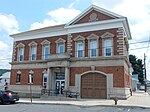
W. Broad St., Tamaqua, PA

Tamaqua (, Delaware: tëmakwe) is a borough in eastern Schuylkill County in the Coal Region of Pennsylvania, United States. It had a population of 6,934 as of the 2020 U.S. census.Tamaqua was established from territory from West Penn and Schuylkill Townships. The borough is part of the micropolitan statistical area of Pottsville. Tamaqua is located 37.8 miles (60.8 km) northwest of Allentown, 87 miles (140 km) northwest of Philadelphia, and 125.5 miles (202.0 km) west of New York City.

Excerpt from the Wikipedia article Tamaqua, Pennsylvania (License: CC BY-SA 3.0, Authors, Images).

Tamaqua, Pennsylvania
North Greenwood Street,

Geographical coordinates (GPS) Address Nearby Places
placeShow on map

Wikipedia: Tamaqua, PennsylvaniaContinue reading on Wikipedia

Geographical coordinates (GPS)

Latitude Longitude
N 40.798611111111 ° E -75.966388888889 °
placeShow on map

Address

Zion Lutheran Church

North Greenwood Street 109
18252
Pennsylvania, United States
mapOpen on Google Maps

W. Broad St., Tamaqua, PA
Share experience

Nearby Places

Coaldale, Schuylkill County, Pennsylvania

Coaldale is a borough in Schuylkill County, Pennsylvania, United States. Initially settled in 1827, it was incorporated in 1906 from part of the former Rahn Township; it is named for the coal industry—wherein, it was one of the principal early mining centers. Coaldale is in the southern Anthracite Coal region in the Panther Creek Valley, a tributary of the Little Schuylkill River, along which U.S. Route 209 was eventually built between the steep climb up Pisgah Mountain from Nesquehoning (easterly) and its outlet in Tamaqua, approximately five miles to the west. The town is virtually joined at the hip to nearby Lansford, to its immediate east—as both were founded as company towns on lands owned by and mined by the Lehigh Coal & Navigation Company (LC&N) while technically on opposite sides of the county lines. The history, business situation, and fortunes of not just the two, but of three towns, the third being the nearby Summit Hill, located a few thousand feet upslope, were tied in decades of co-development because the LC&N had built the western terminus of the nation's second railroad, the Summit Hill and Mauch Chunk Gravity Railway to ship coal out, and opened multiple mines throughout Coaldale and Lansford and the rest of the Panther Creek Valley in the days when railroads were coming into their own. The town has a bus stop with a mural on one side reading: "Everybody's Goal Is Mine More Coal" and the other side reading: "A Car More a Day Means More Pay". The area on the western border of the borough is known as Seek. There is a historical marker for Mother Jones located in Coaldale, as she organized many strikes and protests on behalf of coal miners around the country for improved pay, safer work environment and child labor laws. She organized a march for child workers that started in Coaldale and proceeded to McAdoo. At one trial for Mary Jones, a prosecution lawyer famously said, "there sits the most dangerous woman in America... to put down their tools and walk out". Herbert Whildin was elected mayor in 2017.

Panther Creek Valley

In eastern Pennsylvania, the Little Schuylkill River, a tributary of Panther Creek, was historically important due to its stranglehold on energy transportation in a key region central to the American Industrial Revolution from the 1820s through the 1870s, and remained important as an energy producing region until the American steel industry began its rapid decline in the 1980s. Panther Creek Valley lies between and over the Anthracite ladened folds of the two long near parallel ridgelines, Nesquehoning and Pisgah Ridges forming the side walls and supplying the wealth which shipped from the Panther Creek Valley making the region historically important, as for several decades its land owners, Lehigh Coal & Navigation Company (LC&N) held a virtual monopoly on Anthracite produced and shipped not only to eastern U.S. Cities via the Lehigh Canal, but to transoceanic markets. For perspective, LC&N must be viewed as a high-tech company of its day, as well as an early American conglomerate with efforts in many fields; a company which, from its start shortly after people learned to get Anthracite to burn, moved aggressively intelligently using emerging technologies to exploit the marked fuel shortage developing in post-revolutionary era cities and towns; wherein local wood bearing lands had gradually become scarce driving up the price of firewood, including charcoal needed for the fledgling North American iron foundries and dependent manufacturing industries from Boston to Richmond. The twin needs of heating buildings and heat for industrial processes began reshaping the world using technology by the middle of the eighteenth century in Europe—eventually giving rise to public and privately funded canal projects, the use of coal, pumps so coal could be mined, steam engines, and finally rail roads—all initially coming about, so people and industries could have and use heat, overcoming the energy crises of their respective areas & eras. While somewhat delayed in time from the older fuel crises plaguing Great Britain, and continental Europe, the growing fuel shortages in Eastern U.S. cities and young industrial systems from 1800 onwards applied the same pressures; causing the same solutions to be considered locally as well, and were widely debated as public policies as the American System and implemented in part by both local business interests, and the various state governments. Business interests and local governments in the young United States, were highly intertwined and there was much regional competitiveness. So there is little surprise to find such as the Pennsylvania, New York, and Maryland legislatures all put into place proactive programs to enhance transportation penetration to the new frontiers, the Ohio Country and Northwest Territories as American's looked west and plotted settlements, manufactories, and the mindset in business was still much influenced by Mercantilism and its beliefs of a static limited market, so were focused on growing industries using the internal markets of newly settled western lands. Well before the presidential election of 1824 gave a renewed impetus to economic philosophies now called the American School, Philadelphia region private interests armed by newly publicized know-how of how to successfully ignite and sustain a clean burning fire using Anthracite, took notice of the fuel, its availability (it was discovered locally in the 1790s)...

Pisgah Mountain
Pisgah Mountain

Pisgah Mountain, or Pisgah Ridge on older USGS maps, is a ridgeline running 12.5 miles (20.1 km) from Tamaqua to Jim Thorpe, Pennsylvania from the Little Schuylkill River water gap to the Lehigh River water gap. The mountain runs north-northeast to south-southwest, and its north-side valley is followed by U.S. Route 209 from river gap to river gap. The ridge is a succession of peaks exceeding 1,440 feet (438.9 m) rising 300 to 540 feet (91 to 165 m) above the boroughs of Lansford, Coaldale, and Tamaqua in the Panther Creek valley. The highest point on Pisgah Mountain is at 1,611 feet (491 m) in the borough of Summit Hill, which sits atop the ridge. Near Summit Hill was the "Sharpe Mountain" (peak) where in 1791 Phillip Ginter is documented as having discovered anthracite, leading to the formation of the Lehigh Coal Mine Company. In 1818 the Lehigh Coal Company took over the mines, and the mining camp gradually became a settlement and grew into Summit Hill. Pisgah Ridge forms the left bank drainage divide of Panther Creek to its south and the stream's source in Summit Hill. The peak at the east end of the ridge is named Mount Pisgah and represents a hard rock knob that towers 800 feet (240 m) above the Lehigh River to the east.Pisgah Ridge is entirely in the Delaware River watershed. The western part of the north side of the ridge feeds Panther Creek running to the west as a Little Schuylkill River tributary, while the eastern part of the north side drains to Nesquehoning Creek, a tributary of the Lehigh River, which flows past the east end of the mountain. The eastern end of the south side of the mountain drains into the valley of Mauch Chunk Creek (White Bear Creek), while the western part of the south side drains to Owl Creek, which flows west to the Little Schuylkill. Mount Pisgah is joined by Nesquehoning Mountain, a ridge of similar height, near their eastern end, at a 1,540-foot (470 m) summit between the centers of Jim Thorpe and Nesquehoning. The bulk of Nesquehoning Mountain is separated from Mount Pisgah proper by a short and very steep valley that US-209 climbs from the borough of Nesquehoning westwards 2–3 miles (3–5 km) to reach the head of the Panther Creek valley in Lansford. The railroad tracks paralleling PA-54 also transiting the town of Nesquehoning's flat river-bank terrain takes over 16 miles (26 km) farther to climb and descend to once again reach an elevation where it can turn to enter the Panther Creek Valley near the confluence with the Little Schuylkill via the rail yard at Tamaqua in a longer more circuitous climb—and demonstration why dump trucks have replaced railroads in short-haul situations.