Durris Forest
Aberdeenshire stubsForests and woodlands of ScotlandUse British English from August 2017

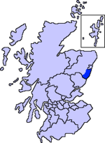
Durris Forest is a chiefly coniferous forest south of the River Dee approximately three kilometres west of Netherley in Aberdeenshire, Scotland. The A957 road forms the southwest boundary of Durris Forest, separating it from Fetteresso Forest. The Durris Forest includes several smaller named woodlands. The ancient route of Elsick Mounth crosses the Grampian Mounth within the Durris Forest. Notable natural features in the vicinity include Red Moss and Meikle Carewe Hill. Notable historic features in this area include Raedykes Roman Camp, Muchalls Castle and Maryculter House.
Excerpt from the Wikipedia article Durris Forest (License: CC BY-SA 3.0, Authors, Images).Durris Forest
Geographical coordinates (GPS) Address Nearby Places Show on map
Geographical coordinates (GPS)
| Latitude | Longitude |
|---|---|
| N 57.028 ° | E -2.349 ° |
Address
Woodlands of Durris
AB31 6AD
Scotland, United Kingdom
Open on Google Maps


