Liverpool Town Hall

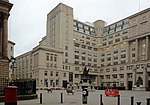
Liverpool Town Hall stands in High Street at its junction with Dale Street, Castle Street, and Water Street in Liverpool, Merseyside, England. It is recorded in the National Heritage List for England as a designated Grade I listed building, and described in the list as "one of the finest surviving 18th-century town halls". The authors of the Buildings of England series refer to its "magnificent scale", and consider it to be "probably the grandest ...suite of civic rooms in the country", and "an outstanding and complete example of late Georgian decoration".It is not an administrative building but a civic suite, Lord Mayor's parlour and Council chamber; local government administration is centred at the nearby Cunard Building. The town hall was built between 1749 and 1754 to a design by John Wood the Elder replacing an earlier town hall nearby. An extension to the north designed by James Wyatt was added in 1785. Following a fire in 1795 the hall was largely rebuilt and a dome designed by Wyatt was built. Minor alterations have subsequently been made. The streets surrounding its site have altered since its initiation, notably when viewed from Castle Street, the south-side, it appears as off-centre. This is because Water Street which ran to the junction with Dale Street, the west-east axis, was continuous and built up across the junction so that the town hall was not visible originally from that aspect. The structures were removed 150 years after this to expose the building from this position. The ground floor contains the city's Council Chamber and a Hall of Remembrance for the Liverpool servicemen killed in the First World War. The upper floor consists of a suite of lavishly decorated rooms which are used for a variety of events and functions. Conducted tours of the building are arranged for the general public and the hall is licensed for weddings.
Excerpt from the Wikipedia article Liverpool Town Hall (License: CC BY-SA 3.0, Authors, Images).Liverpool Town Hall
High Street, Liverpool Ropewalks
Geographical coordinates (GPS) Address Website External links Nearby Places Show on map
Geographical coordinates (GPS)
| Latitude | Longitude |
|---|---|
| N 53.4071 ° | E -2.9916 ° |
Address
Liverpool Town Hall
High Street
L2 3SW Liverpool, Ropewalks
England, United Kingdom
Open on Google Maps


