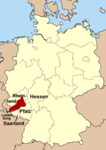
The Hunsrück (German pronunciation: [ˈhʊnsʁʏk] ) is a long, triangular, pronounced upland in Rhineland-Palatinate, Germany. It is bounded by the valleys of the Moselle-Saar (north-to-west), the Nahe (south), and the Rhine (east). It is continued by the Taunus mountains, past the Rhine and by the Eifel past the Moselle. To the south of the Nahe is a lower, hilly country forming the near bulk of the Palatinate region and all of the, smaller, Saarland. Below its north-east corner is Koblenz.
As the Hunsrück proceeds east it acquires north-south width and three notable gaps in its southern ridges. In this zone are multi-branch headwaters including the Simmerbach ending at Simmertal on the southern edge. This interior is therefore rarely higher than 450 metres (1,480 ft) above sea level. Peaks and escarpments are principally: the (Black Forest) Hochwald, the Idar Forest, the Soonwald, and the Bingen Forest. The highest mountain is the Erbeskopf (816 m; 2,677 ft), towards the region's south-west.
Notable towns are Simmern, Kirchberg, and Idar-Oberstein, Kastellaun, and Morbach. Frankfurt-Hahn Airport is at the centre of the upland, equidistant between Mainz, Trier and Koblenz, co-named after the village of Hahn.
Slate is still mined in the mountains. Since 2010, the region has become one of Germany's major onshore wind power regions. Large wind farms are near Ellern and Kirchberg. Nature-based tourism is widespread. In 2015, a new national park was inaugurated. The pedestrian Geierlay suspension bridge opened in the same year. The climate sees mists that rise most mornings. More rain than the German average is caused by a combination of an oceanic influence and relief precipitation.
Culturally, the region is best known for its Hunsrückisch dialect and through depictions in the Heimat film series. The region saw great emigration in the mid-19th century, particularly to Brazil.

