place

Serpent Mounds Park

1st millennium in CanadaArchaeological sites in OntarioFirst Nations in OntarioGeography of Peterborough CountyMounds
National Historic Sites in OntarioParks in OntarioPoint Peninsula ComplexProtected areas of Peterborough CountyTourist attractions in Peterborough CountyUse Canadian English from January 2023
Serpent Mounds NHS
Serpent Mounds NHS

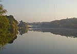
Serpent Mounds Park is a historical place located near Keene, Ontario, Canada. Serpent Mounds operated as a provincial park, established in 1955 through a lease with the Hiawatha First Nation, of the Michi Saagiig (Mississauga Anishinaabeg). In 1982, while operating as a provincial park the mounds were designated a National Historic Site, including East Sugar Island. From 1995 to 2009, Hiawatha First Nation operated the park privately, offering camping facilities, beach access on Rice Lake, a cultural center, and interpretive walks among the historic serpent and nearby mounds. The park was closed to the public in 2009, due to the decline in the tourism and deteriorating infrastructure.

Excerpt from the Wikipedia article Serpent Mounds Park (License: CC BY-SA 3.0, Authors, Images).

Serpent Mounds Park
Knotts Landing, Otonabee–South Monaghan

Geographical coordinates (GPS) Address External links Nearby Places
placeShow on map

Wikipedia: Serpent Mounds ParkContinue reading on Wikipedia

Geographical coordinates (GPS)

Latitude Longitude
N 44.209166666667 ° E -78.154722222222 °
placeShow on map

Address

Serpent Mounds Provincial Park

Knotts Landing
K0L 2G0 Otonabee–South Monaghan
Ontario, Canada
mapOpen on Google Maps

linkWikiData (Q29919251)
linkOpenStreetMap (14205495)

Serpent Mounds NHS
Serpent Mounds NHS
Share experience

Nearby Places

Rice Lake (Ontario)
Rice Lake (Ontario)

Rice Lake is a lake located in Northumberland and Peterborough counties in south-eastern Ontario. The lake is located south of the city of Peterborough, and the Kawartha Lakes and north of Cobourg. It is part of the Trent-Severn Waterway, which flows into the lake by the Otonabee and out via the Trent. The lake is 28 kilometres (17 mi) long and 5 km wide. Its maximum depth is 10m, with a surface water level at 187 m above sea level, raised to its present height by the Hastings Dam, built in the 19th century as part of the Trent-Severn canal system. Natives called it Pemadashdakota or "lake of the burning plains". A drumlin field is located northwest of the lake, and the lake's islands are partially submerged drumlins. Rice Lake nearly bisects the Oak Ridges Moraine, with three wedges to the west (Albion, Uxbridge and Pontypool), and one wedge to the east (Rice Lake) which has terminus at the Trent River. A narrow corridor to the south of Rice Lake connects these wedges.Rice Lake is fairly shallow and was named for the wild rice which grew in it and was harvested by native people of the area. Most of the extensive stands of wild rice originally found in here were wiped out when water levels were raised in the lake by the construction of the waterway. The village of Bewdley sits on the west end of the lake and the town of Hastings sits on the east. Prehistoric burial mounds are found at Serpent Mounds Park on the north shore of the lake. Other places of interest include the Native Reserves of Alderville and Hiawatha. Other communities include Roseneath, Bailieboro, Gores Landing, Keene, Ontario and Harwood.