place

Arkleby

Cumbria geography stubsPlumblandUse British English from September 2019Villages in Cumbria
Arkleby Hall, Arkleby geograph.org.uk 48542

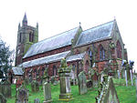
Arkleby is a village in Cumbria, England. It is located about 1 mile south of Aspatria and 9 miles south-west of Wigton. Arkleby is part of the civil parish of Plumbland and is a short distance from the village of Parsonby and larger village of Plumbland. Arkleby Hall, a farmhouse, dates from 1725 and is a Grade II listed building. St Cuthbert's Church, the parish church of Plumbland, is located in between Arkleby and Parsonby. The church was built in 1871 by J.A. Cory, incorporating the fabric of an earlier 13th century church on the site; it is a Grade II listed building.

Excerpt from the Wikipedia article Arkleby (License: CC BY-SA 3.0, Authors, Images).

Arkleby
Parsonby Brow,

Geographical coordinates (GPS) Address Nearby Places
placeShow on map

Wikipedia: ArklebyContinue reading on Wikipedia

Geographical coordinates (GPS)

Latitude Longitude
N 54.73 ° E -3.33 °
placeShow on map

Address

Parsonby Brow

Parsonby Brow
CA7 2DD
England, United Kingdom
mapOpen on Google Maps

Arkleby Hall, Arkleby geograph.org.uk 48542
Share experience

Nearby Places

Aspatria
Aspatria

Aspatria is a town and civil parish in Cumberland, Cumbria, England. The town rests on the north side of the Ellen Valley, overlooking a panoramic view of the countryside, with Skiddaw to the South and the Solway Firth to the North. Its developments are aligned approximately east–west along the A596 Carlisle to Workington road and these extend to approximately 2 miles (3.2 km) in length. It lies about 8 miles (13 km) northeast of Maryport, a similar distance to the Southwest of Wigton, about 9 miles (14 km) north of Cockermouth and 5 miles (8.0 km) from the coast and Allonby. It comprises the townships of Aspatria and Brayton, Hayton and Mealo, and Oughterside and Allerby, the united area being 8,345 acres (3,377 ha); while the town takes up an area of 1,600 acres (647 ha). In earlier days a Roman road leading from "Old Carlisle" to Ellenborough passed through the hamlet. The population has greatly increased since the mid-19 century. In 1801, the village comprised 98 dwellings with a population of 321. By 1851, there were 236 family entities, comprising 1,123 residents; by 1871, the numbers had increased to 1,778; and twenty years later stood at 2,714. By the start of the 20th century, the population had risen to 2,885; twenty years later it peaked at 3,521. Although the population slumped in the 1930s to 3,189, it recovered to 3,500, in 1951; and by 1981, the population appeared stable at 2,745. It is served by Aspatria railway station. Aspatria is located on the fringe of the English Lake District. The parish church of St Kentigern was completed in 1848. Fragments of masonry and crosses from earlier structures on the same site are preserved there.