Ogdensburg, New York

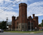
Ogdensburg is a city in St. Lawrence County, New York, United States. The population was 10,436 at the 2019 census. In the late 18th century, European-American settlers named the community after American land owner and developer Samuel Ogden. The city is at the northern border of New York at the mouth of the Oswegatchie River on the south bank of the St. Lawrence River. The only formally designated city in the county, it is located between Massena, New York to the east and Brockville, Ontario to the west. The port of Ogdensburg is the only U.S. port on the St. Lawrence Seaway. The Ogdensburg–Prescott International Bridge, northeast of the city, links the United States and Canada, with a direct highway from Prescott to Ottawa, the capital of Canada.
Excerpt from the Wikipedia article Ogdensburg, New York (License: CC BY-SA 3.0, Authors, Images).Ogdensburg, New York
Greene Street, City of Ogdensburg
Geographical coordinates (GPS) Address Nearby Places Show on map
 Continue reading on Wikipedia
 Geographical coordinates (GPS)
| Latitude | Longitude |
|---|---|
| N 44.7 ° | E -75.483333333333 ° |
Address
Greene Street 913
13669 City of Ogdensburg
New York, United States
Open on Google Maps