place

Minerva's Shrine, Chester

2nd-century religious buildings and structuresArchaeological sites in CheshireBuildings and structures in ChesterGrade I listed buildings in ChesterHistory of Chester
Religious buildings and structures in EnglandReligious buildings and structures in the United KingdomRoman religious sites in EnglandRoman sites in CheshireScheduled monuments in CheshireShrinesTemples of MinervaUse British English from October 2017
Minerva's Shrine
Minerva's Shrine

Minerva's Shrine is a shrine to the Roman goddess Minerva in Edgar's Field, Handbridge, Chester, England. It is recorded in the National Heritage List for England as a designated Grade I listed building. The shrine dates from the early 2nd century and is carved into the face of a sandstone quarry. It is the only monument of its kind in Western Europe that remains in its original location. It is protected by a 19th-century stone surround with a hood, which was refurbished in the late 20th century. The carving has weathered over the centuries and has also been damaged by human activity. Next to the shrine is an opening into the rock face which is possibly a natural fissure that has been enlarged and which is known as Edgar's Cave.The shrine stands beside the route of the old main Roman road into the fortress of Deva from the south. Minerva was the Roman goddess of war, knowledge, and craftsmanship. She is often depicted with her attributes of helmet, shield, breastplate, and spear, but in this instance she is shown in a simplified form, standing in a representation of a temple. The Roman quarry, together with Edgar's Field and the image of Minerva, is a Scheduled Monument.A cast of the shrine is kept in the Grosvenor Museum, in Chester.

Excerpt from the Wikipedia article Minerva's Shrine, Chester (License: CC BY-SA 3.0, Authors, Images).

Minerva's Shrine, Chester
Edgar Place, Chester Handbridge

Geographical coordinates (GPS) Address External links Nearby Places
placeShow on map

Wikipedia: Minerva's Shrine, ChesterContinue reading on Wikipedia

Geographical coordinates (GPS)

Latitude Longitude
N 53.1843 ° E -2.8893 °
placeShow on map

Address

Minerva Roman rock shrine

Edgar Place
CH4 7JY Chester, Handbridge
England, United Kingdom
mapOpen on Google Maps

linkWikiData (Q6864464)
linkOpenStreetMap (403887883)

Minerva's Shrine
Minerva's Shrine
Share experience

Nearby Places

Chester Weir
Chester Weir

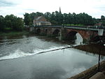
Chester Weir is a weir which crosses the River Dee at Chester, Cheshire, England, slightly upstream from the Old Dee Bridge (grid reference SJ407658). The weir and the associated salmon leap are recorded in the National Heritage List for England as a designated Grade I listed building.This was originally the site of a causeway across the River Dee. The weir was built in sandstone in 1093 for Hugh Lupus, 1st Earl of Chester, for the Benedictine Abbey of St Werburgh (now Chester Cathedral). It was designed to provide a head of water for the medieval mills on the river. The mills were demolished during the 20th century and the weir was restored to serve the Chester City Council's hydro-electric power station, which operated from 1913 to 1939 on the site of the former mills.The weir continues to provide three essential roles in maintaining the very substantial water abstractions from the River Dee. It prevents tidal water ingress up-river for all but the highest tides; it provides the water head for an abstraction immediately behind the weir and it holds back what is a long linear lake which enables that largest abstraction to be taken at Huntington for the United Utilities supply to the Wirral and surrounding areas.The weir can be navigated by crossing over the top during high spring tides. On the city-side of the weir is the United Kingdom's only example of a weirgate, a low height single lock gate that can be opened to provide extra draft once the water levels on each side of the weir have equalised. This allows carefully planned passage from the non-tidal River Dee, via the short tidal estuary section, onto the Dee Branch of the Shropshire Union Canal (originally the Chester Canal) at certain times of year.United Utilities vacated the turbine building in 2015, ending its use as a pump station, and allowing installation of a new hydro electric generating plant, planning for which is underway as of 2021, alongside a Green-Energy education centre and visitor attraction.