place

Arledge Mounds I and II
Adena cultureArchaeological sites in OhioArchaeological sites on the National Register of Historic Places in OhioGeography of Pickaway County, OhioMounds in Ohio
National Register of Historic Places in Pickaway County, OhioUse mdy dates from August 2023
ArledgeMoundsIandII
ArledgeMoundsIandII

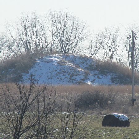
The Arledge Mounds are a pair of Native American mounds in the south central part of the U.S. state of Ohio. Located near Circleville in Pickaway County, the two mounds lie in the middle of a farm field, far from any roads. These two mounds are disparate in size: while the smaller mound's height is 5 feet (1.5 m), the other's is 20 feet (6.1 m), and their diameters are approximately 65 feet (20 m) and 120 feet (37 m) respectively.: 1140 Most unusual is the proximity of the mounds to each other — while many groups of mounds are known in Ohio,: 1238, 1362, 1371  they are not typically connected at the base as these two mounds are; only the Arledge Mounds and the McMurray Mounds, which straddled the border between Franklin and Madison counties, are known to have been conjoined. Although these mounds have not been excavated, archaeologists have proposed that they were built by the Adena culture, who are known to have built the McMurray Mounds.: 1141 As undisturbed works of the Adena or some other mound building culture, the Arledge Mounds are potentially a valuable archaeological site. In recognition of this fact, they were listed on the National Register of Historic Places in 1974.

Excerpt from the Wikipedia article Arledge Mounds I and II (License: CC BY-SA 3.0, Authors, Images).

Arledge Mounds I and II

Geographical coordinates (GPS) Address Nearby Places
placeShow on map

Wikipedia: Arledge Mounds I and IIContinue reading on Wikipedia

Geographical coordinates (GPS)

Latitude Longitude
N 39.55 ° E -82.874166666667 °
placeShow on map

Address

Thacher


Ohio, United States
mapOpen on Google Maps

ArledgeMoundsIandII
ArledgeMoundsIandII
Share experience

Nearby Places

Gill–Morris Farm
Gill–Morris Farm

The Gill–Morris Farm is a historic farmstead near the city of Circleville in Pickaway County, Ohio, United States. Established in the early nineteenth century, it has been named a historic site. In 1798, U.S. President John Adams appointed a Mr. Winship the Registrar of Lands in the south-central portion of the Northwest Territory. Winship acquired 1,440 acres (580 ha) within this region, which he divided among three of his sons. In 1827, one of them, William, conveyed part of his share to his sister Nancy Winship Gill. On this property the present farmstead had been established seven years earlier, and five years later the Gills expanded the house. In 1928, a descendant donated a small parcel at the front of the property to the Daughters of the American Revolution: here, the DAR erected a small monument to the Camp Charlotte Treaty, which had been signed by Chief Cornstalk and Lord Dunmore.The farmhouse is a brick structure, with a foundation of limestone, although other buildings on the property are log structures. While the farmhouse as originally built was a clear example of the Federal style, the 1832 renovation gave the residence an appearance influenced by the later Greek Revival style. Both styles are still evident in the architecture: the double chimneys on the ends of the house and bull's-eye elements in the original lintels are distinctive Federal details, while the trabeated main entrance, windows, and flat lintels in the addition are more clearly Greek Revival.In 1986, the Gill–Morris Farm was listed on the National Register of Historic Places. The designation encompassed four contributing properties (three buildings and the monument) spread across 150 acres (61 ha); the farm qualified for inclusion because of its distinctive historic architecture.

Luthor List Mound
Luthor List Mound

The Luthor List Mound (also known as the "Burning Mound" or the "Signal Mound") is an archaeological site of the Adena culture in the southern part of the U.S. state of Ohio. Located in Pickaway County near the city of Circleville, this Native American mound sits along the Kingston Pike, southeast of Circleville in Circleville Township.As one of the largest burial mounds in Pickaway County, the Luthor List Mound is believed to contain the skeletons of many leading members of the society that built it. The mound's location on top of a small ridge, far from major bodies of water, is indicative that it was built by Adenan peoples, who often buried their chieftains in mounds such as the Luthor List Mound. Such mounds were typically built in stages: individuals would be buried within small mounds, and the resulting mound cluster would be covered with earth and converted into a single large mound.Unlike many of the region's conical mounds, the Luthor List Mound has seen very little damage since white settlement of the region. Located on a ridgeline, the mound sits at an elevation of 735 feet (224 m). With a diameter of at least 75 feet (23 m) in all directions, it is 12 feet (3.7 m) high; the erosion caused by the plows of past farmers has not damaged the Luthor List Mound because of its location — sitting atop the ridgeline and covered with trees, it is not an ideal farming location. In recognition of its archaeological value, the Luthor List Mound was listed on the National Register of Historic Places in 1974.