place

Washington Heights School

Buildings and structures in Hamilton County, OhioGreater Cincinnati school stubsHamilton County, Ohio Registered Historic Place stubsIndian Hill, OhioNational Register of Historic Places in Hamilton County, Ohio
School buildings on the National Register of Historic Places in Ohio
WashingtonHeightsSchool2

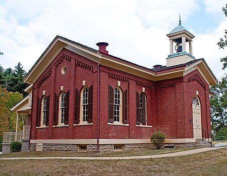
Washington Heights School is a registered historic building in Indian Hill, Ohio, listed in the National Register on July 30, 1975. The Washington Heights School is one of five sites in Indian Hill that is listed on the National Register, along with the Elliott House, the Jefferson Schoolhouse, the Gordon E. Pape House, and the Methodist church.

Excerpt from the Wikipedia article Washington Heights School (License: CC BY-SA 3.0, Authors, Images).

Washington Heights School
Given Road,

Geographical coordinates (GPS) Address Nearby Places
placeShow on map

Wikipedia: Washington Heights SchoolContinue reading on Wikipedia

Geographical coordinates (GPS)

Latitude Longitude
N 39.204347222222 ° E -84.324388888889 °
placeShow on map

Address

Given Road 8280
45243
Ohio, United States
mapOpen on Google Maps

WashingtonHeightsSchool2
Share experience

Nearby Places

Elliott House (Indian Hill, Ohio)

The Elliott House is a historic residence in the city of Indian Hill in northeastern Hamilton County, Ohio, United States. Constructed in 1802, this farmhouse once served as the hub of an industrial operation, and since that time it has been named a historic site.Native of Ireland, John Elliott left Londonderry for the United States in 1784. He married Mary Miller in Pennsylvania, in 1786. They soon settled along the Little Miami River in present-day northeastern Hamilton County, Nearly twenty years later, they built the core of the present structure as a farmhouse; built of stone, it consisted of a simple rectangular floor plan with chimneys on each end. Soon after the original portion was completed, the Elliotts added a wing to the southwestern corner of the original house. Later modifications included enclosure of the rear porch, replacement of the tiny original front porch with a far larger structure, and construction of a hallway to serve the rear addition.Having completed his house, Elliott proceeded to construct an industrial complex on his property. Following the placement of a dam on the Little Miami, he established a gristmill, a distillery, a carding mill for wool, and a sawmill on the property. Using these facilities, Elliott began to engage in business at great distances; many of his products were sold in New Orleans after transportation down the Ohio and Mississippi Rivers.In 1898, the property was bought by a family named Sterrett, who occupied it for more than twenty years; after they sold it to Henry Livingston in 1920, he donated it to a Jewish social agency, which maintained a summer camp around the house into the 1960s. In 1967, the village of Indian Hill purchased the land; for many years, it was used as an educational center for schoolchildren, and in 1976, the Elliott House was listed on the National Register of Historic Places. It qualified for inclusion on the Register because of its place in local history, for it is one of the oldest houses in the Miami Purchase, and also because of its well-preserved historic architecture. Soon afterward, a widescale restoration effort took place: all recent additions were removed, the original elements were restored, and the surrounding property was archaeologically investigated. Finances proved insufficient for more extensive renovations, but the house was in a condition sufficient for occupation, and Indian Hill sold it to private owners in 1985.The Elliott House is one of five sites in Indian Hill that is listed on the National Register, along with the Jefferson Schoolhouse, the Gordon E. Pape House, the Methodist church, and the Washington Heights School.

Camp Dennison
Camp Dennison

Camp Dennison was a military recruiting, training, and medical post for the United States Army during the American Civil War. It was located near Cincinnati, Ohio, not far from the Ohio River. The camp was named for Cincinnati native William Dennison, Ohio's governor at the start of the war. With the outbreak of the Civil War in 1861, George B. McClellan, commander of Ohio's state militia, was charged by Governor Dennison with selecting a site for a recruitment and training center for southern Ohio, a possible target for the Confederate States Army due to its Ohio River location and proximity to slave states such as Kentucky and Virginia, from which invasions could be launched. McClellan was joined by Joshua H. Bates and another member of the militia in preparing the plans for the new camp. The site was actually chosen by then Captain William S. Rosecrans, who chose a level tract of land near Indian Hill, Ohio, 17 miles (27 km) from Cincinnati. The land was on both sides of the Little Miami Railroad (LMR) tracks, which ended at Cincinnati's Public Landing. There are variable area listed, but 700 acres (2.8 km2) of land appears to have been rented from the Buckingham and Nimrod Price families. They were offered $12 to $20 per acre per month, a figure named without negotiation, and considered generous. Rosecrans laid out the camp via survey around April 24, 1861, and a large contingent of recruits from Camp Chase, numbering about 1,500 men were sent by train. The first post commander was Melancthon Smith Wade, a Cincinnatian who was a former general in the Ohio Militia. The LMR could transport volunteers from Central Ohio, and from areas along those tracks. The location had fresh water in the nearby Little Miami River but the recruits had to be trained to use latrines, for in 1862, the United States Sanitary Commission reported that men refused to use latrines, and instead used an area hillside, at the bottom of which was their water supply. It was the Little Miami Railroad which could transport troops quickly into Cincinnati in case of enemy threat. However, among the men initially sent, there were less than a dozen muskets among them, but presumably the Confederates, if they considered attacking Cincinnati, were not aware. The Little Miami Railroad tracks are now a bicycle trail. More than 50,000 Union soldiers were mustered in or out of service at Camp Dennison. As many as 12,000 occupied the camp at any one time. During Morgan's Raid in 1863, troops from Camp Dennison responded to the invasion by Confederate cavalry under Brig. Gen. John Hunt Morgan, as they had in 1862 when Cincinnati was briefly threatened by the cavalry of Albert G. Jenkins. Within the first week, inclement weather made life difficult for the first to arrive. They had no chance to build substantial structures, and the weather turned cold and rainy. The fields became a sea of mud. The camp hospital was established on the ground floor of the Waldschmidt barn, after horses were liveried elsewhere, the manure removed, and fresh straw laid down. Camp Dennison along with its surrounding cities of Indian Hill and Madeira have a curfew of 1 AM, Many men contracted pneumonia, and then there was a measles epidemic. For a time, the "hospital" was simply a shelter, although there was minimal bedding. At least one man died. As the war progressed, shortly after the Battle of Shiloh a military hospital was established on the grounds of Camp Dennison, with over 200 beds situated in a series of wooden barracks. These wooden barracks were originally used to house soldiers, but were converted into hospital wards. There were considerably more men sent there over the course of the war. The nearby Waldschmidt Cemetery served as the temporary gravesite for 340 Union soldiers and 31 Confederate soldiers who were prisoners of war. The bodies were reinterred at Spring Grove Cemetery or at Camp Chase in Columbus in the late 1860s. The end of the Civil War in 1865 eliminated the need for Camp Dennison, which was deactivated in September. A small community, Camp Dennison, sprang up around the camp and hospital. Many of the later barns and homes used lumber and materials from the abandoned army camp. In 1973, two of the remaining buildings from the fort were listed on the National Register of Historic Places as a historic district, the "Waldschmidt-Camp Dennison District."
Yost Tavern
Yost Tavern

The Yost Tavern is a historic former inn in the city of Montgomery, Ohio, United States. Built in 1805, when Montgomery was founded, it remained in operation as a lodging establishment until a long period of use as a house, and it was donated to the city after being owned by the local Kiwanis chapter. It has also been named a historic site. Abraham Yost both lived and operated a tavern in the building, and his business flourished because of its location along the highway to Cincinnati. He built the structure in 1805, the year in which the village of Montgomery was incorporated. Within four years, Columbus-bound traffic was causing business to boom; Yost's customers purchased more than fifty barrels of whiskey in 1809 alone. After Yost, the building became a house alone; White Miller bought it in 1870, and his descendants remained in ownership and in residence until 1968. In the latter year, the community's Kiwanis club purchased the property, donated some of the chattels to the local historical society, and sold the remnant at public auction. The club retained the tavern for just eleven years before giving it to the Montgomery city government in 1979.Architecturally, the tavern is a simple gable-front structure with a rear lean-to. The two-story facade is pierced by four openings (a doorway and window on the first floor, and two windows on the second), with another entrance to the side. The walls are weatherboarded, set on a stone foundation and covered by a metal roof.In 1993, the old tavern was listed on the National Register of Historic Places, qualifying because of its significant importance in community history. It is one of five locations in Montgomery to be listed on the Register, along with the Blair House, the Montgomery Saltbox Houses, the Universalist Church Historic District, and the Wilder-Swaim House. The building also has been designated as a local landmark by the Montgomery city government.