place

Hesel (Samtgemeinde)

East Frisia stubsSamtgemeinden in Lower SaxonyTowns and villages in East FrisiaTowns in Lower SaxonyWeser-Ems region geography stubs
ChurchHesel
ChurchHesel

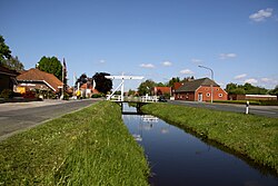
Hesel is a Samtgemeinde ("joint municipality") in the district of Leer, in Lower Saxony, Germany. Its seat is in the village Hesel. The Samtgemeinde Hesel consists of the following municipalities: Brinkum Firrel Hesel Holtland Neukamperfehn SchwerinsdorfThe area lies centrally within the Oldenburg-East Frisian geest ridge. Already in prehistoric and early historic times Hesel was the junction of a road network. It still has this function today in the modern road network of East Frisia. On the territory of the joint municipality there are many of the oldest traces of human settlement of East Frisia. Favoured by its location, the main village of Hesel was the site of two monasteries and several monastery outworks in the High and Late Middle Ages. On January 17, 1972, the six communities mentioned above merged to form the joint municipality of Hesel. Economically, the joint municipality of Hesel is primarily characterized by medium-sized businesses. Agriculture has always played a major role in the joint municipality, as can be seen from the high proportion of agricultural land of more than 75 percent. Tourism plays a role to a certain extent. However, the joint municipality as a whole is a commuter area, especially to the neighboring county seat of Leer. The cultural heritage of the joint municipality includes the 13th century Marienkirche (St. Mary's Church) in Holtland, the former monastery outworks Gut Stikelkamp from the 16th century and several archaeological sites.

Excerpt from the Wikipedia article Hesel (Samtgemeinde) (License: CC BY-SA 3.0, Authors, Images).

Hesel (Samtgemeinde)
Falkenstraße, Samtgemeinde Hesel

Geographical coordinates (GPS) Address Nearby Places
placeShow on map

Wikipedia: Hesel (Samtgemeinde)Continue reading on Wikipedia

Geographical coordinates (GPS)

Latitude Longitude
N 53.3 ° E 7.6 °
placeShow on map

Address

Falkenstraße
26835 Samtgemeinde Hesel
Lower Saxony, Germany
mapOpen on Google Maps

ChurchHesel
ChurchHesel
Share experience

Nearby Places

Pünte (Wiltshausen)
Pünte (Wiltshausen)

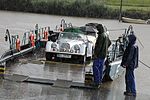
The Pünte in Wiltshausen, part of the borough of Leer in East Frisia, Germany, is a small, hand-operated cable ferry over the River Jümme, close to its confluence with the Leda. It links the villages of Amdorf and Wiltshausen and is believed to be the oldest hand-hauled ferry in Northern Europe.The crossing at Wiltshausen is recorded as being in operation as early as 1562. In former times it ferried horses and carts, cattle, people with bicycles and handcarts.It was used until 1975, its last operator, the county of Leer, then closed it for financial reasons. When its closure was announced in 1974 a citizens' movement formed the "Society for the Preservation of the Historic Pünte As A Monument on the Water" (Verein zur Förderung und Erhaltung der historischen Pünte als Denkmal auf dem Wasser), which restarted the operation of the ferry in 1988. In 2002 the pünte was placed under conservation.From the outset, the society had several hundred local members; later people joined from all over the world, even those who had never seen the pünte themselves. Although the society is voluntary, it has not received any public subsidies since the 1980s. The hand-operated, rope-guided punt-type ferry can transport up to three cars and about 30 foot passengers. Its operating season is from May to early October and Wednesday to Sunday. Today, the pünte is relatively strongly aimed at the tourist trade. The pünte season traditionally begins on 1 May and is celebrated a bit like a folk festival. Other pünten in the county of Leer, in Halte, Hilkenborg, Esklum and Loga, had been closed before the pünte at Wiltshausen.