Rosedale, North Yorkshire

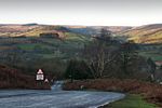
Rosedale is a valley located almost in the centre of the North York Moors national park in North Yorkshire, England. The nearest town is Kirkbymoorside, some 7 miles (11 km) to the south. Rosedale is surrounded by moorland. To the north-west sits Blakey Ridge at over 1,300 feet (400 m) above sea level. At Dale Head is the source of the River Seven,which flows down the valley to join the River Rye at Little Habton near Malton. At its southern end Rosedale is squeezed between Spaunton Moor and Hartoft Rigg, where the river flows out through Forestry Commission woodland before passing the village of Cropton to reach the plains of the Vale of Pickering. The modern village of Rosedale Abbey, built around the site of a former Cistercian Priory is the main settlement in the valley. There is also a small hamlet at Thorgill.
Excerpt from the Wikipedia article Rosedale, North Yorkshire (License: CC BY-SA 3.0, Authors, Images).Rosedale, North Yorkshire
Daleside Road,
Geographical coordinates (GPS) Address Nearby Places Show on map
Geographical coordinates (GPS)
| Latitude | Longitude |
|---|---|
| N 54.351 ° | E -0.894 ° |
Address
Daleside Road
Daleside Road
YO18 8SE , Rosedale West Side
England, United Kingdom
Open on Google Maps


