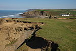
RAF Cleave
Military history of CornwallMorwenstowRoyal Air Force stations in CornwallRoyal Air Force stations of World War II in the United KingdomUse British English from May 2013
RAF Cleave is a former Royal Air Force station located 4.2 miles (7 kilometres) north of Bude in Cornwall, United Kingdom, which was operational from 1939 until 1945. Despite a few periods of intense activity, it was one of Fighter Command's lesser used airfields.
Excerpt from the Wikipedia article RAF Cleave (License: CC BY-SA 3.0, Authors).RAF Cleave
Cleave Crescent,
Geographical coordinates (GPS) Address Nearby Places Show on map
Geographical coordinates (GPS)
| Latitude | Longitude |
|---|---|
| N 50.885555555556 ° | E -4.55 ° |
Address
WW2 RAF Cleave Anti-Aircraft Gunnery Training Site
Cleave Crescent
EX23 9JH , Morwenstow
England, United Kingdom
Open on Google Maps


