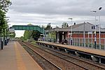
Woodley, Greater Manchester
Areas of Greater ManchesterGeography of the Metropolitan Borough of Stockport

Woodley is a suburb in the Metropolitan Borough of Stockport, Greater Manchester, England. It is situated on the east side of the Peak Forest Canal, next to Bredbury, Romiley and the boundary with Tameside, at Gee Cross. Historically part of Cheshire, the name means "a clearing in the wood" because the area contains a lot of woodland.
Excerpt from the Wikipedia article Woodley, Greater Manchester (License: CC BY-SA 3.0, Authors, Images).Woodley, Greater Manchester
Needwood Road,
Geographical coordinates (GPS) Address Nearby Places Show on map
Geographical coordinates (GPS)
| Latitude | Longitude |
|---|---|
| N 53.427 ° | E -2.092 ° |
Address
Needwood Road
Needwood Road
SK6 1LG , Woodley
England, United Kingdom
Open on Google Maps


