place

Wingst

Cuxhaven geography stubsMunicipalities in Lower SaxonyPages including recorded pronunciationsPages with German IPA
Wingst in CUX
Wingst in CUX

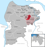
Wingst (German pronunciation: [vɪŋst] ) is a municipality in the district of Cuxhaven, in Lower Saxony, Germany. Wingst belonged to the Prince-Archbishopric of Bremen, established in 1180. In 1648 the Prince-Archbishopric was transformed into the Duchy of Bremen, which was first ruled in personal union by the Swedish Crown - interrupted by a Danish occupation (1712–1715) - and from 1715 on by the Hanoverian Crown. In 1807 the ephemeric Kingdom of Westphalia annexed the Duchy, before France annexed it in 1810. In 1813 the Duchy was restored to the Electorate of Hanover, which - after its upgrade to the Kingdom of Hanover in 1814 - incorporated the Duchy in a real union and the Ducal territory, including Wingst, became part of the new Stade Region, established in 1823.

Excerpt from the Wikipedia article Wingst (License: CC BY-SA 3.0, Authors, Images).

Wingst
Weißenmoor, Samtgemeinde Land Hadeln

Geographical coordinates (GPS) Address Nearby Places
placeShow on map

Wikipedia: WingstContinue reading on Wikipedia

Geographical coordinates (GPS)

Latitude Longitude
N 53.716666666667 ° E 9.0666666666667 °
placeShow on map

Address

Weißenmoor

Weißenmoor
21789 Samtgemeinde Land Hadeln, Ellerbruch
Lower Saxony, Germany
mapOpen on Google Maps

Wingst in CUX
Wingst in CUX
Share experience

Nearby Places

Deutscher Olymp
Deutscher Olymp

The Deutscher Olymp is a 62-metre-high elevation on the Wingst ridge within the boundary of the homonymous municipality in the district of Cuxhaven in the German state of Lower Saxony. The Deutscher Olymp was formed from an ice age moraine. On its summit is a 29-metre-high observation tower, from where there are views of the River Elbe and the North Sea. The hill known as the Deutscher Olymp ("German Mount Olympus") was given this name in 1852 by an innkeeper, thus renaming the 61-metre-high Fahlenberg. In 1974 its wooden observation tower was replaced by a 29-metre-high concrete viewing tower, which now enabled a view from a height of 90 m of the countryside around Kehdingen and Land Hadeln through glass panes. A lift is provided. In good weather, ships can be seen on the Elbe making their way to Hamburg. On the limit of visibility to the northwest is Cuxhaven with its telecommunication tower, the Friedrich Clemens Gerke Tower and the twin towers of the church in Altenbruch. To the north may be seen the North Sea, the Elbe, the mouth of the Oste and the coast of Schleswig-Holstein with the Brunsbüttel nuclear power station and the large wind farm. From northeast to east the course of the Oste as far as Hemmoor can be seen, from southeast to south are the geest hills of the Westerberg and the Balksee lake. From southwest to west is the expanse of the Hadeln Marsh; its villages are recognisable from their church towers with the aid of a map. The tower was closed from autumn 2005 to February 2006, because the associated inn was up for sale, but did not find any buyers for a long time. From summer 2006 the observation tower was opened from time to time in cooperation with the municipality of Am Dobrock.