Mannheim Harbour

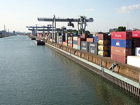
Mannheim Harbour, named Rhein-Neckar-Hafen Mannheim, is a river port on the Rhine in Mannheim, at the confluence of the Rhine and the Neckar in Baden-Wurttemberg. It consists out of 4 main harbour areas Handelshafen, Rheinauhafen, Altrheinhafen and Industriehafen, which are divided into 14 single harbour basins and 3 river docks. It is one of the most important inland ports in Europe. The port covers 3.42 km² of water (2.83 km² Rhine, 0.59 km² Neckar) and 8.635 km² of dockland. The total land area covered from the harbour is about 11.31 km², making it the biggest inland port in Germany based on this measure.The Rhein-Neckar-Hafen Mannheim reflects a trimodal transport node at the junction of road and rail inks and two national waterways and offers various transhipment facilities. The 4 main harbour areas have overnight rail connections to all German and many important European commercial centres and it can be accessed by road via several main motorways.
Excerpt from the Wikipedia article Mannheim Harbour (License: CC BY-SA 3.0, Authors, Images).Mannheim Harbour
Diffenéstraße, Mannheim Neckarstadt-West (Neckarstadt-West)
Geographical coordinates (GPS) Address Nearby Places Show on map
Geographical coordinates (GPS)
| Latitude | Longitude |
|---|---|
| N 49.516944444444 ° | E 8.4675 ° |
Address
Diffenéstraße 12
68169 Mannheim, Neckarstadt-West (Neckarstadt-West)
Baden-Württemberg, Germany
Open on Google Maps


