place

Southampton, Massachusetts

1753 establishments in the Thirteen ColoniesPages including recorded pronunciationsPopulated places established in 1753Southampton, MassachusettsSpringfield metropolitan area, Massachusetts
Towns in Hampshire County, MassachusettsTowns in Massachusetts
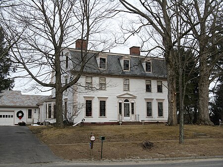
Woodbridge Hall, Southampton MA

Southampton ( (listen)) is a town in Hampshire County, Massachusetts, United States. It was established first as a district of Northampton in 1732. It was incorporated in 1775. The name Southampton was given to it during its first town meeting in 1773. Its ZIP code is 01073. Southampton is part of the Springfield, Massachusetts Metropolitan Statistical Area. The town had a population of 6,224 at the 2020 census.Southampton was rated having the best tasting tap water in the country in 2008 by the National Rural Water Association.U.S. Senator Ted Kennedy was involved in a plane crash in the town in 1964.

Excerpt from the Wikipedia article Southampton, Massachusetts (License: CC BY-SA 3.0, Authors, Images).

Southampton, Massachusetts
College Highway,

Geographical coordinates (GPS) Address Nearby Places
placeShow on map

Wikipedia: Southampton, MassachusettsContinue reading on Wikipedia

Geographical coordinates (GPS)

Latitude Longitude
N 42.229166666667 ° E -72.730555555556 °
placeShow on map

Address

College Highway 214
01073
Massachusetts, United States
mapOpen on Google Maps

Woodbridge Hall, Southampton MA
Share experience

Nearby Places

Lockville Historic District

The Lockville Historic District is a historic district encompassing the area of a historic mill village in Southampton, Massachusetts. The district is located about 1 mile (1.6 km) south of Southampton Center along College Highway (Massachusetts Route 10), in the area where the road crosses the Manhan River. The river in this area provided a drop in elevation that was used to provide power for a modest mill complex, which operated from the 1830s until about 1900. The district includes the house of the first documented mill family, the Ichabod Strong House (c. 1786), the Lyman Mill (established c. 1854), Lyman Pond and the dam that impounds it (built in 1838 after a flood washed out the previous dam).The area also includes a sheet metal factory established by the Lyman family in 1894. This business became more prominent after the mills were forced to close due to a loss of water power after the city of Holyoke began drawing water from the river. There is also a remnant of the c. 1835 New Haven and Northampton Canal, which traversed three locks in the area, giving it its name. Other features associated with the canal include a former hotel building, a storehouse (both now private residences), and the remains of one of the locks.The areas around Lyman Pond are thought to include industrial archeological remnants from mills that may have been established as early as 1732. The district was listed on the National Register of Historic Places in 2001.

Rock Valley, Holyoke, Massachusetts

Rock Valley, sometimes referred to as West Holyoke, is a neighborhood in Holyoke, Massachusetts located to the west of the city center, approximately 3 miles (4.8 km) from downtown, bordering Easthampton, Southampton, Westfield, and West Springfield. Rock Valley is historically Holyoke's second oldest village after Elmwood, with its eponymous burial ground dating to around 1777, and families having settled in the area as early as 1745. Predating the construction of the Hadley Falls Dam, it originated as the western section of the 3rd parish ("Ireland Parish") of West Springfield. Today the neighborhood contains several historic Federal and Colonial homesteads, in addition to many modern developments adjacent to agricultural and wetland tracts.Even into the 20th century the area retained an agrarian character, but was met with concern by residents who believed their neighborhood to be falling behind the progress made by the rest of the city during its sudden industrial growth. In 1921, the West Holyoke Improvement Association was founded by a number of concerned for the purpose of representing the interests of the neighborhood before the city government. Renamed the Rock Valley Improvement League in 1955, among the issues they lobbied for was the electrification of streets lights in the area, construction of a community center, and development of new playgrounds for children. The association would hold many neighborhood dinners and events for a number of years as well, and having achieved many of the aforementioned goals fell into relative obscurity. In 1930 the area briefly gained international attention when a former supply route to Westfield built by soldiers of the 104th Infantry was dedicated in Massachusetts as the Apremont Highway in a joint ceremony between Holyoke and Westfield. The 104th was the first American military unit to receive a foreign decoration for valor and the first foreign recipients of the French Croix de Guerre, for liberating Apremont-la-Forêt in the First World War.

Main Street Historic District (Easthampton, Massachusetts)

The Main Street Historic District of Easthampton, Massachusetts encompasses the historic heart of the town, running along Main Street between Northampton and Center Streets. The area has been the civic and economic heart of the town since incorporation in 1785. Most of the commercial buildings date from the 1840s to the 1880s, and are built in an Italianate style. The housing stock of the district also includes Italianate styling, but there are also a number of Greek Revival structures. The major civic structures of the town are in the district, including the town hall (brick, Italianate), public library (designed in 1881 by Peabody & Stearns in the Old English style), and the First Congregational Church, which is the second for the congregation, a brick Romanesque Revival building dating to 1851. The district was added to the National Register of Historic Places in 1986.Easthampton was settled in the early 18th century, and was separately incorporated out of parts of Northampton and Southampton in 1786. At first economically an agricultural community, its town center developed around its first meeting house, located about 1/4-mile south of the Manhan River, where an early gristmill and settlement were located. Substantial growth in the town center began in the 1840s, when a boys' seminary was founded, and a button factory was founded on a tributary of the Manhan River southeast of the center, which was dammed to form what is now called Nashawannuck Pond[1]. This was the seed of a corridor of industrial development just east of the center, which grew in the mid-19th century along with this economic growth.