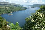
Kyles of Bute

The Kyles of Bute (Scottish Gaelic: Na Caoil Bhòdach) form a narrow sea channel that separates the northern end of the Isle of Bute from the Cowal Peninsula in Argyll and Bute, on the Scottish mainland. The surrounding hillsides are roughly wooded, and overlooked by rocky tops and areas of moorland. The Kyles are split into the East and West Kyles. The East Kyle (Scottish Gaelic: An Caol an Ear) runs from Rothesay Bay north west up to the entrance to Loch Riddon. Here at the northern end of the East Kyle are the Burnt Islands and the island of Eilean Dubh. The West Kyle (Scottish Gaelic: An Caol an Iar/An Caol Ceathrach) runs from here southwest, past the village of Tighnabruaich out to the Sound of Bute. The area is a designated National Scenic Area. The Kyles are reflected in the name of Tighnabruaich-based Shinty team Kyles Athletic.
Excerpt from the Wikipedia article Kyles of Bute (License: CC BY-SA 3.0, Authors, Images).Kyles of Bute
Geographical coordinates (GPS) Address Nearby Places Show on map
Geographical coordinates (GPS)
| Latitude | Longitude |
|---|---|
| N 55.93 ° | E -5.187 ° |
Address
Buttock Point
PA21 2EH
Scotland, United Kingdom
Open on Google Maps


