place

Buxheim, Swabia

Municipalities in BavariaSwabia (Bavaria) geography stubsUnterallgäu
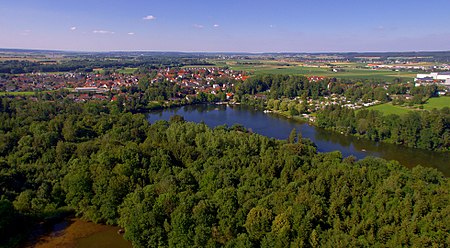
Buxheim Karthäusersee

Buxheim is a municipality in the district of Unterallgäu in Bavaria, Germany.

Excerpt from the Wikipedia article Buxheim, Swabia (License: CC BY-SA 3.0, Authors, Images).

Buxheim, Swabia
Kirchplatz,

Geographical coordinates (GPS) Address Nearby Places
placeShow on map

Wikipedia: Buxheim, SwabiaContinue reading on Wikipedia

Geographical coordinates (GPS)

Latitude Longitude
N 48 ° E 10.133333333333 °
placeShow on map

Address

Rathaus

Kirchplatz 2
87740
Bavaria, Germany
mapOpen on Google Maps

Buxheim Karthäusersee
Share experience

Nearby Places

Buxach (Iller)
Buxach (Iller)

Buxach is a river of Bavaria, Germany. The Buxbach is a right tributary of the Iller and about 16.7 kilometres (10.4 mi) long. Its source is southeast of the municipality of Kronburg, near the Einöde Heißenschwende. The Buxach is straightened only few places in Hart and Buxach (two districts of Memmingen), most of its course it flows freely. The river banks are surrounded by forests and villages as well as meadows. The Buxach feeds the Buxheimer Weiher, a reservoir north of Buxheim. The water of the Buxheimer Weiher does not flow back into the Buxach, but into the Reutenbach. The Buxach itself flows west from Buxheim on the Illerstadion into the Iller. In former times, the Buxach also fed the Memminger municipal pond southward of Hart. The pond was drained around 1900, today still the name of the street "Am Stadtweiher" ("at the municipal pond") is a reminder. Especially in Hart and Buxach, the river was used for industry. In Hart, there was a copper hammer, and several mills and copper hammers existed in Buxach. At the east of Kronburg, an oil mill was operated. At Buxheim, west of the pond Buxheimer Weiher, the river Reutenbach diverges from the Buxach. Only very little water flows through that direct connection; the Reutenbach is mostly fed by the outflow of the Buxheimer Weiher, which is 200 meters (660 ft) away. The Reutenbach flows northwards through Buxheim and feeds a fish pond near Egelsee (district of Memmingen), then also flows into the river Iller. The mouth of the Reutenbach in the Iller is about 2.3 kilometres (1.4 mi) north from the mouth of the Buxach.

Memmingen
Memmingen

Memmingen (German: [ˈmɛmɪŋən] ; Swabian: Memmenge) is a town in Swabia, Bavaria, Germany. It is the economic, educational and administrative centre of the Danube-Iller region. To the west the town is flanked by the Iller, the river that marks the Baden-Württemberg border. To the north, east and south the town is surrounded by the district of Unterallgäu (Lower Allgäu). With about 42,000 inhabitants, Memmingen is the 5th biggest town in the administrative region of Swabia. The origins of the town go back to the Roman Empire. The old town, with its many courtyards, castles and patricians' houses, palaces and fortifications is one of the best preserved in southern Germany. With good transport links by road, rail and air, it is the transport hub for Upper Swabia and Central Swabia, and the Allgäu. Due to its proximity to the Allgäu region, Memmingen is often called the Gateway to the Allgäu (Tor zum Allgäu). The town motto is Memmingen – Stadt mit Perspektiven ("Memmingen – a town with perspectives"). In recent times it has been frequently referred to as Memmingen – Stadt der Menschenrechte (Memmingen – the town of human rights). This alludes to the Twelve Articles, considered to be the first written set of human rights in Europe, which were penned in Memmingen in 1525. Every four years there is the Wallensteinfestspiel, with about 4,500 participants, the biggest historical reenactment in Europe. It commemorates the invasion of Wallenstein and his troops in 1630.