place

St. Regis Park, Kentucky

1953 establishments in KentuckyCities in Jefferson County, KentuckyCities in KentuckyPopulated places established in 1953Use mdy dates from July 2023
Jefferson County Kentucky Incorporated and Unincorporated areas St. Regis Park Highlighted 2167998

St. Regis Park is a home rule-class city in Jefferson County, Kentucky, United States, and a part of the Louisville Metro government. The population was 1,454 as of the 2010 census.

Excerpt from the Wikipedia article St. Regis Park, Kentucky (License: CC BY-SA 3.0, Authors, Images).

St. Regis Park, Kentucky
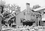
Lincoln Road, St. Regis Park

Geographical coordinates (GPS) Address Nearby Places
placeShow on map

Wikipedia: St. Regis Park, KentuckyContinue reading on Wikipedia

Geographical coordinates (GPS)

Latitude Longitude
N 38.228888888889 ° E -85.615833333333 °
placeShow on map

Address

Lincoln Road 4421
40220 St. Regis Park
Kentucky, United States
mapOpen on Google Maps

Jefferson County Kentucky Incorporated and Unincorporated areas St. Regis Park Highlighted 2167998
Share experience

Nearby Places

Hikes Point, Louisville

Hikes Point is a neighborhood in eastern Louisville, Kentucky, USA. Its boundaries are I-264 to the north, Breckenridge Lane to the west, and irregular boundaries to the other sides. The area was settled by American Revolutionary War veteran George Hikes in 1791 on land sold to him by William Meriwether. Hikes was born in 1761 in Lancaster County, Pennsylvania. After serving in the Revolutionary War, serving under James Cook's Company of Fourth Battalion of Militia in Lancaster County, PA; he moved to Louisville Kentucky with his four young sons, John, Jacob, Andrew and George, three daughters and his wife Barbara Oleweiler. Hikes built a number of homes on this land to include; a stone home named Two Mile Town another one is now St. Michael's Antioch (a family cemetery is on the grounds) was one of the original stone houses in the Hikes family, later willed to Andrew Hikes, George's youngest son. (Source: Jefferson Count, Kentucky Will Book 2, page 484.) One original Hikes family home was demolished in August 2013. It was a log cabin built around 1851, previously occupied by John E's Restaurant (and prior to that, Bill Boland's Restaurant) at the corner of Bardstown Road and Hikes Lane. The log walls of the building had been plastered over, but many of the massive log walls were uncovered when the restaurant opened in the 1980s. There is also a Hikes family cemetery to the side of the building. Hikes opened grist and saw mills as the community grew and a cloth industry developed in the early 19th century.In the early 20th century developers bought up much of the land surrounding Hikes' home, but there was little interest in the area until after World War II. Roy McMahan purchased the nearby Eberle family farm in 1946 and built several subdivisions and shopping centers, some of which bear his name, and Hikes Point has long been a strong retail area. Hikes Point was also the original home of Southeast Christian Church, which grew to become one of the largest Christian congregations in the U.S., although it has long since moved from the area. Since their move away from Hikes Point, the area has been home to Canaan Missionary Baptist Church which moved from the Shively area of the city to Hikes Point in 1998, one of the largest Baptist churches in Kentucky, with over 6500 members.

Low Dutch Station
Low Dutch Station

Low Dutch Station was established in 1780 on the middle fork of Beargrass Creek in Kentucky. This station was settled by Dutch pioneers from Pennsylvania and was also known as New Holland Station. The station was one of a group of seven forts established on Beargrass Creek during this period in this area that is now a part of Louisville. The leader of the group was Hendrick Banta. The group of settlers were a part of the "Low Dutch Company" and had their own bylaws, a formal charter, and accounting procedures. The group had as its purpose the preservation of the language, culture and religion of the Dutch. The Dutch traveled from a settlement near Harrodsburg to Low Dutch Station. There is no connection between Low Dutch Station or its settlers and the nearby road known as Dutchmans Lane in St. Matthews. The aforementioned Dutchmans Lane was originally named Deutschman's Lane, taking its name from the fact that it was the access road from Taylorsville Road to the farm owned and operated by Louis J. Hollenbach Sr., a prominent German-American businessman in early 20th-century Louisville. Anti-German sentiment in Louisville during World War I prompted the shortening of the name from Deutschman (lit. "German man") to Dutchman. The bronze plaque historical marker for Low Dutch Station is located on the south side of Kresge Way, about 200 ft. east/northeast of the traffic light intersection where Browns Lane & Baptist Hospital East Emergency Entrance crosses Kresge Way. It could also be described as being 200 ft. east of the northwest corner of Browns Park, and the marker actually is at the edge of Browns Park, next to the road and sidewalk right-of-way. This marker and its post had been missing for some time, and has since been replaced with a new marker with a slightly different wording, counting it as one of "seven" pioneer forts along Beargrass Creek instead of the previously worded "six". The new marker also eliminated references to "Indians" and the Dutch settlers moving to Henry and Shelby Counties and buying land there from Squire Boone. The text of the new marker reads as follows: In 1780 Hendrick Banta led a large group of Dutch settlers down the Ohio River to the Falls of the Ohio from Pennsylvania. They rented land from John Floyd and built Low Dutch (New Holland) Station, one of seven forts on Beargrass Creek. In 1810, leading agriculturalist James Brown of Maryland, acquired the property.