Depot Town

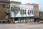
Depot Town is a commercial area, with some residences above storefronts, in Ypsilanti, Michigan's historic district. Depot Town proper consists of East Cross Street from the Huron River to North River Street, and a small area on the 300-block of North River Street. However, several blocks in the surrounding area are also commonly referred to as part of Depot Town. These areas include Riverside Park, Frog Island Park (both of which are on the Huron River), and River Street extending north and south for several blocks. First established in the late 1830s, most of the buildings standing today were constructed between 1850 and 1880. Over the years, Depot Town has included hotels, an Underground Railroad station, an American Civil War barracks, and a building that has housed a bar and restaurant continuously for more than 150 years, switching to soft drinks during Prohibition. Today the area is dominated by restaurants and stores. Depot Town also hosts several large summer festivals each year, as well as weekly bike nights and cruise nights.
Excerpt from the Wikipedia article Depot Town (License: CC BY-SA 3.0, Authors, Images).Depot Town
East Cross Street, Ypsilanti
Geographical coordinates (GPS) Address Nearby Places Show on map
Geographical coordinates (GPS)
| Latitude | Longitude |
|---|---|
| N 42.245961 ° | E -83.609143 ° |
Address
Sidetrack Bar & Grill
East Cross Street 56
48198 Ypsilanti
Michigan, United States
Open on Google Maps


