place

Ida, Michigan

1844 establishments in MichiganCensus-designated places in MichiganCensus-designated places in Monroe County, MichiganPopulated places established in 1844Unincorporated communities in Michigan
Unincorporated communities in Monroe County, MichiganUse mdy dates from July 2023
IdaTownshipMI 2020
IdaTownshipMI 2020

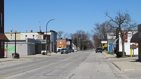
Ida is an unincorporated community and census-designated place (CDP) in Monroe County in the U.S. state of Michigan. The CDP had a population of 790 at the 2020 census. The community is mostly within Ida Township with a smaller portion extending north into Raisinville Township. As an unincorporated community, Ida has no legal autonomy of its own but does have its own post office with the 48140 ZIP Code.

Excerpt from the Wikipedia article Ida, Michigan (License: CC BY-SA 3.0, Authors, Images).

Ida, Michigan
Lewis Avenue,

Geographical coordinates (GPS) Address Nearby Places
placeShow on map

Wikipedia: Ida, MichiganContinue reading on Wikipedia

Geographical coordinates (GPS)

Latitude Longitude
N 41.910833333333 ° E -83.573611111111 °
placeShow on map

Address

Lewis Avenue 2804
48140
Michigan, United States
mapOpen on Google Maps

IdaTownshipMI 2020
IdaTownshipMI 2020
Share experience

Nearby Places

Old Mill Museum (Dundee, Michigan)

The Old Mill Museum, also known as the Alfred Wilkerson Grist Mill, is a historic structure located along the River Raisin at 242 Toledo Street in Dundee, Michigan. It was designated as a Michigan Historic Site on August 3, 1979. It was later listed as a contributing property within the Dundee Historic District, which was added to the National Register of Historic Places on August 20, 1990.Referred to as the oldest and most notable landmark in Dundee, it is the Dundee Historic District's only inclusion (along with the surrounding park) on the opposite of the river from the rest of the downtown area. While the facility itself was not built until the 1849, the dam upon which it is located was first constructed in 1827 and rebuilt in 1846. It is the largest of several dams located along the River Raisin — the majority of which are in nearby Monroe. The facility first served as a gristmill for the growing milling industry in Dundee. Later, the building was converted to produce hydroelectricity as the village's only source of power around 1910. As the oldest surviving structure in Dundee, it was almost demolished in 1934 after years of disuse. Automotive magnate Henry Ford purchased the building and restored it at great cost as part of his village industries program. His only addition to the original three-story structure was the addition of a single-story structure on the side of the building. He converted the mill into a small factory to produce welding tips for his industry, and he was known to make many visits to Dundee. His interest in Dundee was an experiment to see if small towns could be used for his massive, global industry. After Ford's death in 1947, support for this small factory diminished, and it was sold in 1954 to the Wolverine Manufacturing Company, where the building was converted once more to produce paper products. The Wolverine Manufacturing Company used the facility until 1970, when they sold it to the village of Dundee for $1. The village revamped the structure and its surrounding 13.8 acres (5.6 ha) for public use as a museum and park. Although the property is praised for its historical nature, it is not listed on the National Register of Historic Places in its own right. The museum offers ghosts tours and paranormal investigations. The Old Mill Museum is also the location of the annual Old Mill ParaFest.
Dundee Historic District

The Dundee Historic Village is a historic district located in Dundee, Michigan. The district was added to the National Register of Historic Places on August 20, 1990. This area is commonly referred to as the downtown area of Dundee and was settled almost concurrently with the Old Village Historic District in nearby Monroe. Both were built in their respective locations due to the River Raisin. Originally, the buildings within the district were small, wood buildings, but these were eventually replaced with two-story, brick storefronts. Most of the surviving buildings were built between 1866 and 1900, although the district traces its origins to Dundee's establishment in 1825.The district itself is located about one mile east of US-23 along M-50 (known locally as West Monroe Street east of the river and Tecumseh Street to the west of the river) at the bend of the River Raisin. The majority of the district is on the north side of the river— including Riley, Ypsilanti, East Main, and Tecumseh Streets. South of the river includes a small portion of West Monroe and Toledo Streets. The district is colloquially known as the “Triangle District” for the unique shape of the grid plan where Riley and Tecumseh streets intersect at a 45° angle to produce a triangular piece of land cut off by Park Place on the west. The original owners of this triangular plot of land donated it to the village with the promise that it remain undeveloped as a park in the center of the growing community. Today, the triangle is known as Memorial Park, complete with a naval cannon and bandstand.