place

Waimanalo Beach, Hawaii

Beaches of OahuCensus-designated places in Honolulu County, HawaiiPopulated coastal places in Hawaii
Oahu windward side beach

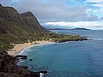
Waimānalo Beach is a census-designated place (CDP) located in the City & County of Honolulu, in the District of Koʻolaupoko, on the island of Oʻahu in the U.S. state of Hawaiʻi. This small windward community is located near the eastern end of the island, and the climate is dry. As of the 2020 census, the CDP had a population of 4,823. This neighborhood is close to, but somewhat separate from Waimānalo, although the two form a single community. Waimānalo Beach (the town) lies along the eastern half of Waimānalo Beach (the beach), with an overall length of nearly 5.5 mi (8.9 km), the longest stretch of sandy shoreline on Oʻahu. Waimānalo Beach has sparse commercial development along Kalanianaole Highway, and is noteworthy for its local flavor and proximity to Makapuʻu Beach and Sea Life Park, which lie closer to Makapuʻu Point at the east end of the island of Oʻahu. There are no hotels here.The U.S. postal code for Waimānalo Beach and Waimānalo is 96795. Kazuo Sakamaki, the first prisoner of war taken by U.S. forces during World War II, was captured on December 8, 1941, on Waimānalo Beach the day after the surprise attack on Pearl Harbor and surrounding targets in Honolulu by Imperial Japanese Navy forces. The Anderson Estate, which was featured in the TV series Magnum, P.I. as "Robin's Nest", is located in Waimānalo Beach.

Excerpt from the Wikipedia article Waimanalo Beach, Hawaii (License: CC BY-SA 3.0, Authors, Images).

Waimanalo Beach, Hawaii
Kalaniana’ole Highway,

Geographical coordinates (GPS) Address Nearby Places
placeShow on map

Wikipedia: Waimanalo Beach, HawaiiContinue reading on Wikipedia

Geographical coordinates (GPS)

Latitude Longitude
N 21.333611111111 ° E -157.69805555556 °
placeShow on map

Address

Kalapa

Kalaniana’ole Highway
96795
Hawaii, United States
mapOpen on Google Maps

Oahu windward side beach
Share experience

Nearby Places

Bellows Air Force Station

Bellows Air Force Station (Bellows Field) is a United States military reservation located in Waimanalo, Hawaii. Once an important air field during World War II, the reservation now serves as a military training area and recreation area for active and retired military and civilian employees of the Department of Defense. Bellows AFS is operated by Detachment 2, 18th Force Support Squadron of the 18th Mission Support Group based at Kadena Air Base, Okinawa, Japan. Located on the opposite side of Oahu is the similar Pililaau Army Recreation Center, part of the Armed Forces Recreation Centers system. Created in 1917 as the Waimänalo Military Reservation on a former sugarcane plantation, the base was renamed Bellows Field in 1933 after Lt. Franklin Barney Bellows, a World War I war hero. Bellows Field was made a permanent military post in July 1941, and it was one of the airfields targeted during the attack on Pearl Harbor on December 7, 1941. The attack at Bellows Field killed two United States Army Air Forces airmen—George Allison Whiteman and Hans C. Christiansen—and injured six others. One B-17 bomber ("Skipper" 40-2049) was forced to land at Bellows during the attack when Japanese aircraft activity made landing at Hickam Field impossible. Bellows Field was used for recreational gliders in the late 1950s and early 1960s. A truck would tow a glider into the air, then the glider pilot would release the tow cable and then catch updrafts from the prevailing wind blowing inshore and deflecting upwards from the very nearby mountains. In this way the pilot could keep the glider in the air as long as desired. Bellows AFS was also the Air Force transmitter-facility site for long-haul high-frequency radio communications from the late 1950s until HF radio was largely replaced by the military satellite program. HF radio links were established using highly directional Sloping "V" antennas to Clark Air Base, Philippines, and McClellan AFB, California. Message circuits were originated or relayed at Hickam AFB, near Pearl Harbor, and sent to Bellows for re-transmission over the HF systems. The receiver site was geographically separated from the transmitter site to prevent RF interference from the high-power transmitters.

Mānana
Mānana

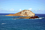
Mānana Island is an uninhabited islet located 0.75 mi (0.65 nmi; 1.21 km) off Kaupō Beach, near Makapuʻu at the eastern end of the island of Oʻahu in the Hawaiian Islands. In the Hawaiian language, mānana means "buoyant". The islet is commonly referred to as Rabbit Island, because its shape as seen from the nearby Oʻahu shore looks something like a rabbit's head and because it was once inhabited by introduced rabbits. The rabbit colony was established by John Adams Cummins in the 1880s when he ran the nearby Waimānalo plantation. The rabbits were eradicated about a hundred years later because they were destroying the native ecosystem, an important seabird breeding area. Mānana is a tuff cone with two vents or craters. The highest point on the islet rises to 361 ft (110 m). The island is 2,319 ft (707 m) long and 2,147 ft (654 m) wide and has an area of about 63 acres (25 ha). Mānana's only sand beach is a small storm beach on the west to south-west (leeward) side of the islet. This sand deposit, located above the reach of the normal waves, is about 30 ft (9.1 m) wide and curves around to the western side of the island. Another volcanic islet named Kāohikaipu sits right next to Mānana. Manana was formed by the Honolulu Volcanic Series. These series of eruptions were responsible for creating other tuff cones such as Punchbowl Crater. Mānana is a State Seabird Sanctuary—home to over 10,000 wedge-tailed shearwaters, 80,000 sooty terns, 20,000 brown noddies, 5–10 Bulwer's petrels, and 10–15 red-tailed tropicbirds, and numerous Hawaiian monk seals. It is illegal to land on the islet without permission from the Hawaiʻi Department of Land and Natural Resources.

Makapuʻu
Makapuʻu

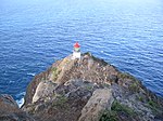
Makapuʻu is the extreme eastern end of the Island of Oʻahu in the Hawaiian Islands, comprising the remnant of a ridge that rises 647 feet (197 m) above the sea. The cliff at Makapuʻu Point forms the eastern tip and is the site of a prominent lighthouse. The place name of this area, meaning "bulging eye" in Hawaiian, is thought to derive from the name of an image said to have been located in a cave here called Keanaokeakuapōloli. The entire area is quite scenic and a panoramic view is presented at the lookout on Kalanianaole Highway (State Rte. 72) where the roadway surmounts the cliff just before turning south towards leeward Oʻahu and Honolulu. The Makapuʻu area is reached approximately 2 kilometers (1.2 mi) east of Waimānalo Beach on Kalanianaole Highway (State Rte. 72) or from the Honolulu side (south shore; Hawaiʻi Kai) travelling east along the same highway beyond Sandy Beach. The Makapuʻu Point State Wayside Park, a 38-acre (15 ha) roadside park, is about midway up the draw on the right-hand side coming from Hawaiʻi Kai. Features of special interest in this area include: Sea Life Park Hawaii – A large commercial park and aquarium featuring displays and shows of Hawaiian marine life.Makapuʻu Point Lighthouse is a 46-foot-tall (14 m), active United States Coast Guard lighthouse established in 1909. Construction for the lighthouse was prompted by the grounding of the steamer Manchuria in the predawn hours on August 20, 1906 on the reefs off Waimānalo. The lighthouse was automated in 1974 and its keepers quarters demolished in 1987, but the remnants are still visible. The lighthouse contains a roughly 12-foot-tall (3.7 m) French Fresnel hyper-radial lens, the largest lens in use in the United States. The lens is able to magnify and intensify the illumination of a single electrical 1,000-watt, 120-volt light bulb. It was damaged by a vandal firing a bullet at it, but the lens is still in service as it is no longer reproducible. A popular day hike along the access road to the lighthouse begins at a parking lot located south of the Makapuʻu lookout on Kalanianaole Highway. A second trail leads from the remnants of the keepers quarters to the lighthouse, but it is off limits to the public. The lighthouse itself is also off limits to the public and is protected by three locked gates. Makapuʻu Point State Wayside is part of the eastern end of Oʻahu encompassing Makapuʻu Head and the lighthouse at Makapuʻu Point. A paved road, open to the public for foot traffic only, leads out to the Makapuʻu Lighthouse. The trail is roughly 1.75 miles (2.82 km) long and rises mostly heading towards the south along the land-side of the ridge and curves around Puʻu o Kīpahulu (southern end of the ridge), then traverses the ridge bearing right towards the lighthouse, which is closed to the public. A trail leads up from the former Coast Guard residential area to a summit from which the islands of Molokaʻi and Lanaʻi may be seen across the Kaiwi Channel. On particularly clear days, the island of Maui can be visible. Of interest to hikers visiting the wayside park is the possibility of seeing Humpback whales in the waters offshore between the months of November and April. A telescope is available to the public at the summit lookout. There are so-called blowholes along the rocky shore below Makapuʻu Head which are sometimes active. Mānana Island is a 63-acre (25 ha) offshore tuff cone known as Rabbit Island because of its resemblance to a large rabbit's head rising out of the sea and because it was once inhabited by introduced rabbits after a rancher released them there. The island is now a protected bird sanctuary and thereby illegal to land there unless you have permission from the Hawaii Department of Land Natural Resources. Kāohikaipu – A low volcanic islet off Makapuʻu Beach Park; also a State Bird Sanctuary.Makapuʻu Beach Park and Kaupō Beach Park – All of the rocky shoreline and pocket beaches between the sea cliffs at Makapuʻu Point and the State Research Pier (Makai Pier) are beach parks open to the public. Wave conditions at Kaupō (western end) are more suited to young beach-goers and poor swimmers. Makapuʻu Beach is a popular body-surfing beach, but the shore break can be dangerous. Makai Pier – A long, concrete pier built by the State of Hawaiʻi to support marine research efforts in the Hawaiian Islands. This pier houses several commercial marine engineering firms and HURL (Hawaiʻi Underwater Research Laboratory). Ka Iwi State Scenic Shoreline - The coastal area that extends from Makapuʻu Point Wayside to Sandy's Beach. Included in this section is Pele's Chair rock formation and the beach/swimming spot that shares the same name.

Maunalua Bay
Maunalua Bay

Maunalua Bay is a bay in the southeast of Honolulu, the capital of Hawaiʻi. The bay extends about 6.3 miles (10.1 kilometers) from the southern tip of Diamond Head, the Black Point, also called Kūpikipikiʻō , in the west to Portlock Point, also known as Kawaihoa Point, to the east. On the land side, just to the east of Diamond Head is the upmarket suburb of Kāhala. Following are several affluent hillside suburbs like Hawaii Loa Ridge, a gated community that occupies an entire slope. In the east is the suburb of Hawaii Kai, built by industrialist Henry J. Kaiser after World War II. Hawaii Kai has a marina, shopping centers, including a Costco, Walgreens, Longs, and Safeway, and numerous restaurants such as the well-known Roy's and Kona Brewing Co. pub. On the headland leading to Koko Head is the suburb of Portlock, which is a part of Hawaii Kai. The name Maunalua (from Mauna = mountain and [ʻe]lua = two, in the native Hawaiian language) refers to the designation of the area what is now referred to as "Hawaii Kai." The mountains, located inland from Portlock Point, are the 645 feet (197 meters) high Koko Head, and about 2.2 miles (3.5 kilometers) east thereof, close to Hanauma Bay the Koko Crater, the walls of which rise up to 1,207 feet (368 meters). According to one legend, Maunalua was one of the first settlements when settlers arrived in Hawaiʻi around the 12th century. Native Hawaiians originally lived there by fishing and cultivating sweet potatoes (ʻuala) along the coastal plains at a place called Ke-kula-O Kamauwai. Maunalua was formerly famous for having the largest Native Hawaiian fishpond (loko iʻa) on Oʻahu. The 523 acre fishpond known as Keahupua-O-Maunalua had a wall or kuapā which originally spanned from Kuliʻouʻou headland and to what is now Portlock. The pond was used primarily to raise mullet (ʻanae) and was also home to a multitude of endemic or indigenous waterbirds. The area continued to be important for fishing and agriculture until the 1950s when the fishpond was filled for housing development.