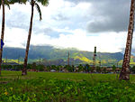
Māʻili (Hawaiian pronunciation: [maːˈʔili]) is a census-designated place (CDP) in the Waiʻanae District on the island of Oʻahu, City & County of Honolulu, Hawaiʻi, United States. In Hawaiian, māʻili means "pebbly", referring to rounded stones at the shore. Māʻili is located along Farrington Highway on Oʻahu's Leeward Coast, between Māʻili Beach Park to the west and Lualualei Valley to the east. It is located 1.4 miles south of the town of Waianae, separated by the Māʻiliʻili Stream, and 1.5 miles north of Nanakuli. As of the 2020 census, the town population was 11,535. Māʻili has one 7-Eleven, a gas station, and a few residential developments. The town is also home to several dairy farms and vegetable plots. Two tall, red antennae near the mouth of the Lualualei Valley are parts of the Navcom Radio Transmitting Facility, and were the tallest man-made structures in the Western Hemisphere at 1,503 feet when they were built in 1972. The town has an elevation of 20 feet (6.1 m).Māʻili has among the highest percentage of Native Hawaiians in Hawai’i, with 48.8% of the population in 2009. Māʻili and its waterfront park, Māʻili Beach Park, is a popular destination for surfing, snorkeling, swimming, boogieboarding, and bodyboarding. Māʻili Beach Park has a total area of forty acres, and is located immediately south of Lualualei Beach Park. The park is home to two popular Hawaiian surf spots: Green Lanterns by the mouth of the Māʻiliʻili Stream, and Tumbleland in the center of the beach park. The water conditions are treacherous during winter-time, but usually calm during summer. The beach park has a lifeguard station, a playground, beach facilities, restrooms, picnic tables, and showers.


