place

Kailua, Hawaii

Census-designated places in Honolulu County, HawaiiPages with Hawaiian IPAPopulated coastal places in HawaiiUse mdy dates from April 2014
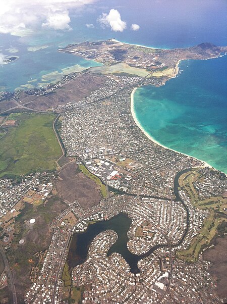
Kailua Aerial
Kailua Aerial

Kailua (Hawaiian pronunciation: [kɐjˈluwə]) is a census-designated place (CDP) in Honolulu County, Hawaii, United States. It lies in the Koʻolaupoko District of the island of Oʻahu on the windward coast at Kailua Bay. It is in the judicial district and the ahupua'a named Ko'olaupoko. It is 12 miles (19 km) northeast of Honolulu – over Nu‘uanu Pali. In the Hawaiian language Kailua means "two seas" or "two currents", a contraction of the words kai (meaning "sea" or "sea water") and ʻelua (meaning "two"); it is so named because of the two former fishponds in the district (Kawainui and Kaʻelepulu) or the two currents that run through Kailua Bay.Kailua is primarily a residential community, with a centralized commercial district along Kailua Road. The population was 50,000 in 1992. In 2017 census, the population had dropped to 38,000. The population was 40,514 at the 2020 census. Places of note in Kailua include Kailua Beach Park, Kaʻōhao or Lanikai Beach, Kawainui Marsh, Maunawili Falls, and Marine Corps Base Hawaii. It was home to Barack Obama’s winter White House.

Excerpt from the Wikipedia article Kailua, Hawaii (License: CC BY-SA 3.0, Authors, Images).

Kailua, Hawaii
North Kainalu Drive, Kailua

Geographical coordinates (GPS) Address Nearby Places
placeShow on map

Wikipedia: Kailua, HawaiiContinue reading on Wikipedia

Geographical coordinates (GPS)

Latitude Longitude
N 21.3975 ° E -157.73944444444 °
placeShow on map

Address

North Kainalu Drive 20
96734 Kailua
Hawaii, United States
mapOpen on Google Maps

Kailua Aerial
Kailua Aerial
Share experience

Nearby Places

Ulupō Heiau State Historic Site

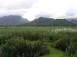
Ulupō Heiau on the eastern edge of Kawai Nui Marsh in Kailua, Hawaiʻi, is an ancient site associated in legend with the menehune, but later with high chiefs of Oʻahu, such as Kakuhihewa in the 15th century and Kualiʻi in the late 17th century. It may have reached the peak of its importance in 1750, before being abandoned after Oʻahu was conquered in the 1780s. The site became a territorial park in 1954, was partially restored in the early 1960s, marked with a bronze plaque by the State Commission on Historical Sites in 1962, and listed on the National Register of Historic Places in 1972.The massive stone platform of the heiau measures 140 by 180 feet (55 m), with outer walls up to 30 feet (9.1 m) high, its size and scale indicating both its cultural importance and the chiefly power of its patrons. Many of the stones may have been transported from as far as Kualoa, more than 10 miles (16 km) away. Although it probably began as an agricultural heiau (mapele) with springs feeding crops of taro, banana, sweet potato, and sugarcane along the fringes of the 400-acre (1.6 km2) Kawai Nui pond full of mullet and other fish. However, the great warrior chief Kualiʻi may have converted it to a heiau luakini, with an altar, an oracle tower (anuʻu), thatched hale, and wooden images (kiʻi).Kailua, with its ample supplies of pond fish, irrigated fields, and canoe landings, was a center of political power for Koʻolaupoko, which often vied with Waialua for control of Oʻahu. After defeating the forces of Oʻahu high chief Kahahana in the 1780s, Maui chief Kahekili lived in Kailua, as did Kamehameha I after conquering Oʻahu in 1795. In later years, Queen Kalama, consort of Kamehameha III, inherited most of the land in Kailua after the death of her husband in 1854, most of it acquired in 1917 by Harold Kainalu Long Castle for his Kaneohe Ranch. The acquisition of land for Kaneohe Ranch brought about changes to the area due to the grazing and ranching of livestock.

Lanikai Beach
Lanikai Beach

Lanikai Beach or Kaʻōhao Beach is located in Kaʻōhao, a community in the town of Kailua and on the windward coast of Oahu, Hawaii. Although there is a widespread belief that the name Lanikai means "heavenly sea", that is a misconception and a grammatical error, since in the Hawaiian language, the qualifier (lani) comes after the noun (kai). The name Lanikai was invented in the 1920s by the developer Charles Frazier, who owned 300 acres of beachfront property in the area known to Native Hawaiians as Kaʻōhao. This small half-mile strip of beach is consistently ranked among the best beaches in the world. Adjacent to Lanikai Beach is a primarily upper-class residential area and because of this it is accessed through public beach access paths. Although the beach itself is public property, it is not state land and is not a county beach park like many beaches in Hawaii. There is no public parking lot and the area lacks facilities like restrooms, showers or lifeguards. As of July 1, 2014, parking violation fines have increased from $35 to $200 in an effort to keep people from illegally parking in the residential area surrounding the beach accesses. Parking violations are strictly enforced and include, but are not limited to, no parking within four feet of a driveway entrance or apron, blocking the unimproved pedestrian right of way (where a sidewalk would normally be), within 30 feet of a stop sign, within ten feet of a fire hydrant, or on or within 20 feet of a crosswalk. However, there are legal parking areas in downtown Kailua. During the weekdays, the beach is less crowded compared to the weekends, although it is still very difficult to find parking close to one of the public beach accesses. On weekends, the beach becomes extremely crowded and during vacation seasons such as winter and summer, the beach is almost completely packed every single day. Lanikai is a popular spot for photo shoots as renowned models and photographers frequent the place on nice days. What makes Lanikai Beach popular for photographers is having the two Islands in the background called the Nā Mokulua or "mokes". Kayakers will often row out to land on the larger northern island, but no one is allowed to land on the southern island as it is a bird sanctuary. Water temperatures are generally 75–80 °F (24–26 °C). It has extremely soft powdery clean white sand. Lanikai Beach is regularly voted as one of the best beaches in America and is the only beach in the USA that was voted as one of the best beaches in the world. Snorkeling in Lanikai Beach is a unique experience for visitors as well as locals due to its pristine seas and a variety of marine life.Due to its position on the Windward or east side of the island, Lanikai is recognized as being a great place to watch the moonrise over the Mokuluas, especially during the full moon. Occasionally during the year the sun will rise directly between the Na Mokulua islands.

Maunawili, Hawaii
Maunawili, Hawaii

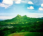
Maunawili (Hawaiian pronunciation: [mɐwnəˈvili]) is a residential census-designated place (CDP) in the City & County of Honolulu, Koʻolaupoko District, Island of Oʻahu, Hawaii, United States. As of the 2020 census, the CDP had a population of 2,026. Situated mauka (inland or mountain side) of Kalanianaʻole Highway between Castle Junction and Castle Hospital, Maunawili is nearly all private homes, schools, and a few churches; horse stables complete the rural setting. There are no commercial establishments. However, residents are only minutes (by car or bus) from Kailua. Maunawili Valley extends behind the prominent windward peak known as Olomana. The residential developments extend only part way back into the valley, which is quite large and fairly wet, supporting limited agriculture (mostly banana growing) behind the housing. Water from the numerous streams is diverted by a ditch to much drier Waimānalo to support agricultural activities there. A golf course and agricultural research station (HSPA) are located in the valley. The agriculture research station is also home to a sugar cane, coffee and cacao breeding program. An attraction of increasing popularity is the Maunawili Demonstration Trail, a state-maintained trail that traverses the breadth of upper Maunawili Valley from the Pali Highway (access at the "Horseshoe Curve") to Waimānalo. A connecting side trail (Maunawili Falls Trail) is accessible from the neighborhood in upper Maunawili. The U.S. postal code for Maunawili is the same as for Kailua: 96734.