place

Nashville Christian School

Christian schools in TennesseeEducational institutions established in 1971Private K–12 schools in TennesseeSchools in Nashville, TennesseeSegregation academies in Tennessee

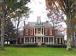
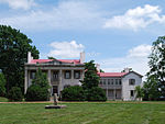
Nashville Christian School (or simply Nashville Christian) is a co-ed private Christian school for ages six weeks through 12th grade located in Bellevue, a neighborhood of Nashville, Tennessee. The school was founded in 1971 as white families sought to avoid having their children bussed across the city with black children during the court ordered desegregation of Nashville public schools.

Excerpt from the Wikipedia article Nashville Christian School (License: CC BY-SA 3.0, Authors).

Nashville Christian School
Sawyer Brown Road, Nashville-Davidson

Geographical coordinates (GPS) Address Website Nearby Places
placeShow on map

Wikipedia: Nashville Christian SchoolContinue reading on Wikipedia

Geographical coordinates (GPS)

Latitude Longitude
N 36.1068 ° E -86.9318 °
placeShow on map

Address

Nashville Christian School

Sawyer Brown Road 7555
37221 Nashville-Davidson
Tennessee, United States
mapOpen on Google Maps

Website
nashvillechristian.org

linkVisit website

Share experience

Nearby Places

Bellevue, Tennessee
Bellevue, Tennessee

Bellevue is a neighborhood of Nashville, situated about 13 miles southwest of the downtown area via Interstate 40. It is served by the Metropolitan Government of Nashville and Davidson County. The 2016 population estimate for Bellevue's two main zip codes was 77,862.In the 1950s, Bellevue was a small community which existed primarily to serve the needs of nearby farms. It was mostly along the railroad tracks near the Harpeth River, and had only a few buildings such as a hardware store, post office, and a Masonic lodge hall. I-40 was built through Bellevue in the early 1960s and suburbanization of the community was made official when the United States Postal Service changed the office's designation from "Bellview, Tennessee" to a branch of the Nashville office in the late 1970s.Since the year 2000, Bellevue has grown in population and development in the established areas along Old Hickory Boulevard, Sawyer Brown Road, McCrory Lane, and Tennessee State Highway 100. Three commercial retail hotspots in the Bellevue area are near the Highway 70S/I-40 interchange, at the intersection of Highway 70S and Old Hickory Boulevard; and near the intersection of Old Harding Pike and Highway 100. Bellevue is a popular destination for nature lovers because of several attractions such as the massive Warner Parks that feature miles of paved and unpaved trails for hikers and cyclists, the Harpeth River Greenway, as well as the beginning access point for the multi-state recreational highway known as the Natchez Trace Parkway. Bellevue is the home to One Bellevue Place, a retail lifestyle center on the property formerly known as Bellevue Center Mall on Highway 70S. This shopping area includes a coffee shop, a hotel and numerous restaurants and retail establishments, anchored by a Sprouts Farmer's Market grocery store, AMC Bellevue 12 theatre, and the Bellevue Community Center and Ford Ice Center.On May 2, 2010, the Bellevue area was hard-hit by a devastating flood, but in the following decade it rebounded and experienced transformative residential and commercial development.

Warner Parks
Warner Parks

Edwin Warner Park and Percy Warner Park, collectively known as Warner Parks, are two major public parks in Nashville, Tennessee. They are part of the park system managed by the Metropolitan Board of Parks and Recreation of Nashville and Davidson County. Percy Warner Park's front entrance is located at the end of Belle Meade Boulevard. The parks are listed on the National Register of Historic Places as Warner Park Historic District. The district is primarily within Nashville along the southern edge of Davidson County, Tennessee, but it extends into Williamson County, Tennessee as well. The two parks are adjacent to each other, separated by Old Hickory Boulevard, and are located approximately 9 mi (14 km) from downtown Nashville. They are bounded on the northwest by Tennessee State Route 100, on the east and north by Chickering Road, and partially on the south by Old Hickory Blvd. and Vaughn Road. The two parks cover 2,684 acres (1,086.2 ha), making the combined parks the second largest municipal park in the state (after Bays Mountain Park in Kingsport which is 3,750 acres). The parks offer a variety of activities, including hiking trails, cross country courses, and an equestrian center.Through funds raised by Friends of Warner Parks, the Warner Parks system added 448 acres in late 2014, expanding the park to more than 3,000 acres. Two properties were purchased for this expansion to enhance the park resources, including the 225-acre Burch Reserve with wooded hills and an old-growth forest previously owned by H. G. Hill Realty. The Burch Reserve is home to Nashville's largest cave in addition to small ponds, meadows and forestry. Ridges and hollows of the former H. G. Hill property are part of what is considered the largest old growth forest in an urban area east of the Mississippi.