place

Santa Barbara, California

1850 establishments in CaliforniaCities in Santa Barbara County, CaliforniaCounty seats in CaliforniaIncorporated cities and towns in CaliforniaPages with non-numeric formatnum arguments
Populated coastal places in CaliforniaPopulated places established in 1850Port cities in CaliforniaSanta Barbara, CaliforniaSpanish mission settlements in North AmericaUse American English from July 2022Use mdy dates from July 2019
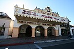
Santa Barbara Downtown (may 2012) (2) (cropped)

Santa Barbara (Spanish: Santa Bárbara, meaning 'Saint Barbara') is a coastal city in Santa Barbara County, California, of which it is also the county seat. Situated on a south-facing section of coastline, the longest such section on the West Coast of the United States, the city lies between the steeply rising Santa Ynez Mountains and the Pacific Ocean. Santa Barbara's climate is often described as Mediterranean, and the city has been dubbed "The American Riviera". According to the 2020 U.S. Census, the city's population was 88,665.In addition to being a popular tourist and resort destination, the city has a diverse economy that includes a large service sector, education, technology, health care, finance, agriculture, manufacturing, and local government. In 2004, the service sector accounted for 35% of local employment.Area institutions of higher learning include the University of California, Santa Barbara, Santa Barbara City College, Westmont College, and Antioch University. The city is served by Santa Barbara Airport and train service is provided by Amtrak, which operates the Pacific Surfliner, which runs from San Diego to San Luis Obispo. The Santa Barbara area is connected via U.S. Highway 101 to Los Angeles 100 mi (160 km) to the southeast and San Francisco 325 mi (525 km) to the northwest. Behind the city, in and beyond the Santa Ynez Mountains, is the Los Padres National Forest, which contains several remote wilderness areas. Channel Islands National Park and Channel Islands National Marine Sanctuary are located approximately 20 miles (30 km) offshore.

Excerpt from the Wikipedia article Santa Barbara, California (License: CC BY-SA 3.0, Authors, Images).

Santa Barbara, California
West Ortega Street, Santa Barbara

Geographical coordinates (GPS) Address Nearby Places
placeShow on map

Wikipedia: Santa Barbara, CaliforniaContinue reading on Wikipedia

Geographical coordinates (GPS)

Latitude Longitude
N 34.416666666667 ° E -119.7 °
placeShow on map

Address

West Ortega Street 129
93101 Santa Barbara
California, United States
mapOpen on Google Maps

Santa Barbara Downtown (may 2012) (2) (cropped)
Share experience

Nearby Places

Casa de la Guerra
Casa de la Guerra

The Casa de la Guerra was the residence of the fifth commandant of the Presidio de Santa Barbara, José de la Guerra y Noriega, founder of the Guerra family of California (a prominent Californio family) from 1828 until his death in 1858. Descendants of José lived in the home until 1943. The site is currently owned and operated by the Santa Barbara Trust for Historic Preservation as a historic house museum. The address is 15 East De la Guerra Street, Santa Barbara, California. The time when José lived in the casa it was known to locals as the casa grande (big house), as the thirteen room structure dwarfed the surrounding one room adobes. In the casa grande period, José added the altito structure. The altito structure no longer stands, but acted as José's office and was where he stored his money. The 1857 Fort Tejon earthquake did significant damage to the residence, and due to José's declining health, his son Pablo spearheaded renovations. Pablo's renovations reflected the change in style in the Santa Barbara area, modifying the home to give it a Victorian appearance. The most significant changes in this time were the removal of the adobe columns in favor of wooden columns and the addition of wooden siding to the house. The Casa is a Santa Barbara City Landmark, a California Historical Landmark. It is listed on the National Register of Historic Places together with Paseo de la Guerra as "El Paseo and Casa de la Guerra". The house is being restored and furnished to appear as it might have between 1828 and 1858. The Casa de la Guerra interior is open to visitors Saturdays and Sundays, although the exterior may be explored any time.