Redlands, California
1888 establishments in CaliforniaAll pages needing cleanupChicano and Mexican neighborhoods in CaliforniaCities in San Bernardino County, CaliforniaIncorporated cities and towns in California ... and 6 more
Populated places established in 1888Populated places in San Bernardino County, CaliforniaPopulated places on the Santa Ana RiverRedlands, CaliforniaUse mdy dates from May 2013Wikipedia introduction cleanup from August 2023

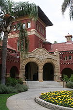
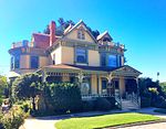
Redlands ( RED-ləndz) is a city in San Bernardino County, California, United States. As of the 2020 census, the city had a population of 73,168, up from 68,747 at the 2010 census. The city is located approximately 45 miles (72 km) west of Palm Springs and 63 miles (101 km) east of Los Angeles.
Excerpt from the Wikipedia article Redlands, California (License: CC BY-SA 3.0, Authors, Images).Redlands, California
West Vine Street,
Geographical coordinates (GPS) Address Nearby Places Show on map
Geographical coordinates (GPS)
| Latitude | Longitude |
|---|---|
| N 34.054722222222 ° | E -117.1825 ° |
Address
West Vine Street 14
92373
California, United States
Open on Google Maps


