place

El Monte, California

1912 establishments in CaliforniaAll pages needing cleanupButterfield Overland Mail in CaliforniaChicano and Mexican neighborhoods in CaliforniaCities in Los Angeles County, California
Communities in the San Gabriel ValleyEl Monte, CaliforniaIncorporated cities and towns in CaliforniaPopulated places established in 1849Populated places established in 1912Wikipedia introduction cleanup from May 2022
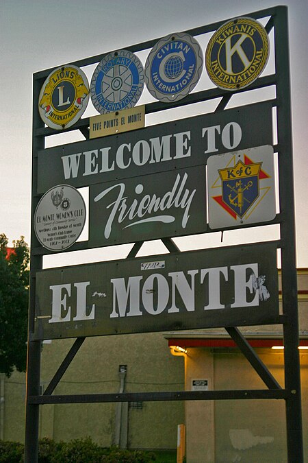
Friendly El Monte
Friendly El Monte

El Monte (Spanish for "The Mountain") is a city in Los Angeles County, California, United States. The city lies in the San Gabriel Valley, east of the city of Los Angeles. El Monte's slogan is "Welcome to Friendly El Monte" and is historically known as "The End of the Santa Fe Trail". As of the 2020 census, the city had a total population of 109,450, down from 113,475 at the 2010 census. As of 2020, El Monte was the 64th-largest city in California.

Excerpt from the Wikipedia article El Monte, California (License: CC BY-SA 3.0, Authors, Images).

El Monte, California
Ramona Boulevard, El Monte

Geographical coordinates (GPS) Address Nearby Places
placeShow on map

Wikipedia: El Monte, CaliforniaContinue reading on Wikipedia

Geographical coordinates (GPS)

Latitude Longitude
N 34.073333333333 ° E -118.0275 °
placeShow on map

Address

Ramona Boulevard

Ramona Boulevard
91732 El Monte
California, United States
mapOpen on Google Maps

Friendly El Monte
Friendly El Monte
Share experience

Nearby Places

Santa Fe Trail Historical Park

Santa Fe Trail Historical Park, also called Pioneer Park, is located on the bank of the Rio Hondo River in El Monte, California. The location was designated a California Historic Landmark (No. 975) on Aug. 13, 1987. This was originally an encampment on the Old Spanish Trail. The Old Spanish Trail was an extension of the trail from Missouri to Santa Fe, New Mexico. The Gila River trail also ended in El Monte. By the 1850s, those in El Monte started to call the town the `End of the Santa Fe Trail." This claim is disputed by some, such as the Santa Fe in New Mexico. In the 1800s permanent settlements were established by immigrants from Texas and Arkansas, the first settlement in Southern California founded by citizens of the United States. The state marker for the Santa Fe Trail Historical Park is located at 3564 Santa Anita Ave, El Monte, CA 91731. The City of El Monte held a ceremony to dedicate the Santa Fe Trail Historical Park on June 2, 1989.El Monte built the (now closed) Santa Fe Trail Historical Park in 1989, near Valley Blvd and Santa Anita Ave. The one-acre park has two historic structures and a covered wagon. The park is on the west side of Santa Anita Avenue, just a few blocks north of the Interstate 10 in California freeway and south of the El Monte City Hall. Soon after it opened, the park closed, and the city has no plans to reopen it. The El Monte Historical Museum at 3150 Tyler Avenue show cases the Santa Fe Trail and El Monte's Historical importance to Southern California.

Walnut Creek (Southern California)

Walnut Creek is an urban stream in the San Gabriel Valley of Southern California, and is a tributary of the San Gabriel River. The creek begins at the Puddingstone Dam of Puddingstone Reservoir in Frank G. Bonelli Regional Park and flows westward for about 13 miles (21 km), through San Dimas, Covina, West Covina and Baldwin Park, to join the San Gabriel River in El Monte. The major tributaries of Walnut Creek are Live Oak Wash (which flows into Puddingstone Reservoir), Charter Oak Creek in Covina, Vine Creek in West Covina and the Big Dalton Wash. Live Oak Wash and Big Dalton Wash carry runoff from the San Gabriel Mountains, and are prone to flooding due to heavy orographic precipitation events in winter. After devastating flooding in the early 20th century, the Los Angeles County Department of Public Works built Puddingstone Dam in 1928 and channelized Walnut Creek and most of its tributaries. However, the first 2 miles (3.2 km) of the creek, in Walnut Creek County Park near San Dimas, are free-flowing and run within a deep wooded canyon.Walnut Creek is a perennial stream, with a significant portion of its flow made up of urban runoff. During dry summers, it provides most of the flow in the San Gabriel River below their confluence. This is due to diversion of the San Gabriel River upstream for groundwater recharge of the San Gabriel Valley aquifer. However, the creek can still dry up during years of particularly poor rainfall. Raging Waters Los Angeles is located adjacent to Walnut Creek just below Puddingstone Dam.